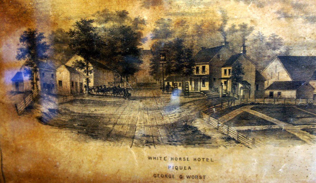
Joseph and Esther and their growing family were well settled. The village of White Horse had grown up around them. Their farming and milling activities provided their sustenance.
The 1730s would prove prosperous for them.


A growing family
In 1730, Joseph had to deal with the death of his mother Elizabeth.
Joseph was about 57 years old. Esther was 32.
There were already three boys in the family – Joseph Jr, John, and Solomon. Joseph and Esther would have five more children by 1740:

- William – b. abt 1730
- Caleb – b. abt 1734
- Joshua – b. abt 1736
- Catherine – b. abt 1738
- James (7G) – b. 1740
Several events occurred during the 1730s that were significant for the Jervises.
The King’s Highway
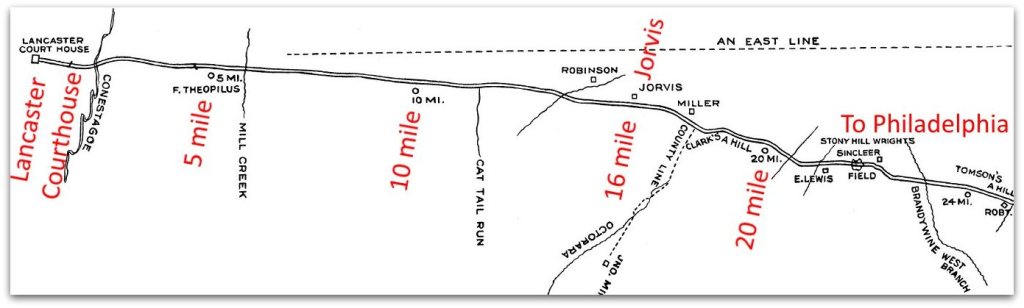
The new town of Lancaster, the county seat, was 16 miles due west. There was a need for a road between Lancaster and Philadelphia.
Roads which were known as “King’s Highways” were laid out by the Governor and Provincial Council, while other roads were left to the counties. This road was to be a main artery to the west, and so was petitioned to be laid out as a King’s Highway.
The best bet was the route along old Peter’s Road (Bezaillion’s trading road). That road went from Philadelphia and Chester west to White Horse, but then turned northwest and bypassed Lancaster. So a new road was surveyed from Lancaster to White Horse, and the old road would be used from White Horse to Philadelphia.
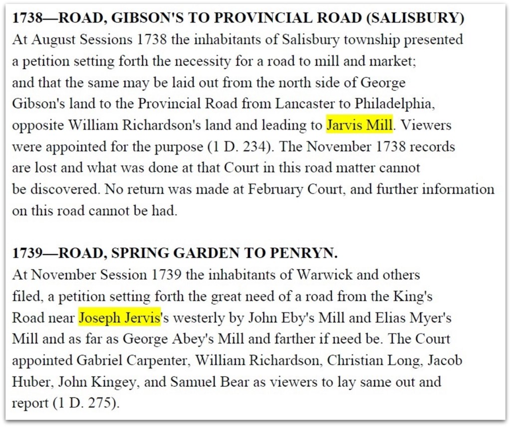
The original 1733 survey showed a hostelry kept by Jervis.
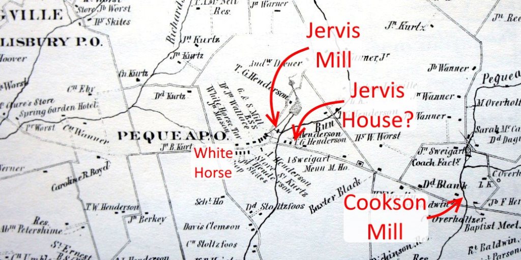
The road passed right by the Jervis house and mill, and also the Cookson house and mill. How fortunate.

A Public House
Joseph and Esther operated a public house along the King’s Highway.

The public house was the internet of its day, with social media postings by every passer-by. No doubt the public house and mill made the Jervises the center of news for White Horse village.
Here’s Joseph’s name on list of recommended persons to keep a public house for 1736.

Seventeen public houses in all of Lancaster County isn’t very many. The reason is that there weren’t many roads. After roads were established, public houses sprang up along them.
Now here’s an interesting research problem. I haven’t done the research, so I’ll throw it out there for a future researcher.
There’s a stone house just east of Joseph’s mill, and it’s on Joseph’s land. It’s reported to have been a public house, and in existence in the mid-1700s. Was this Joseph’s home and public house, or does it post-date him?
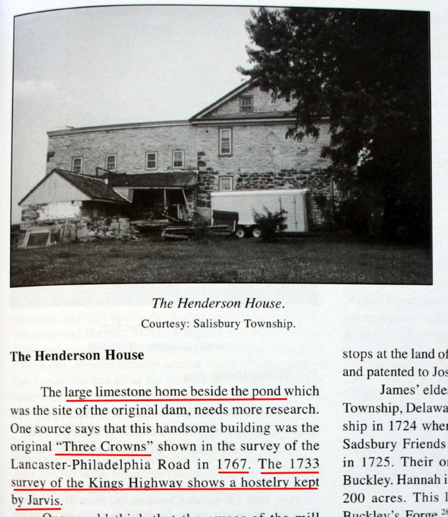
Joseph owned the land until 1750. The house was there during the 1767 survey. Did Joseph build or live in this house?
Here’s the house today.

A land dispute and resolution
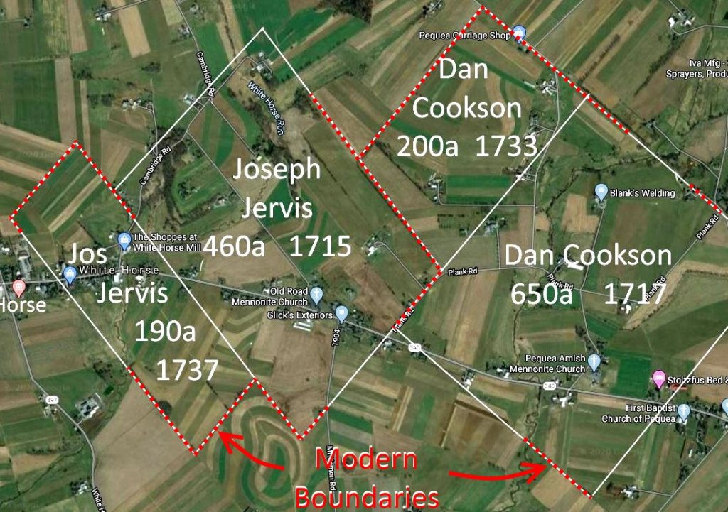
We’ve mentioned earlier that there were lots of land disputes. Sometimes surveys overlapped. Worse, sometimes parts of the same land were warranted to different people.
Such was the case with a warrant that Joseph had been granted in 1714 for land by Chester Creek in Goshen Township. The survey interfered with land granted to Joshua Hastings.
In 1737, the land commissioner’s resolution was to grant Joseph 190 acres adjacent to his land in Pequea. Joseph gave up the 190 acres in Goshen.

So now Joseph had 650 acres in Salisbury Township, Lancaster County.
Meanwhile, Daniel Cookson had acquired an additional 200 acres adjacent to his land. Between them, they held a very large tract.

As I was laying out these land tracts over today’s Google Maps, I was amazed to notice that many of the land boundaries still exist. The modern boundaries are shown on the Google map.
Look at the pattern of the fields in the modern Google Map compared with the boundaries of the 1715 and 1730s tracts. These boundaries have persisted over 300 years.
County Roads
There were many petitions for county roads to intersect the King’s Highway. Those who lived north or south of the main route wanted county roads that led from their farm or mill or business to the King’s Highway.
Many of today’s roads in Lancaster County were petitioned and laid out in the 1720s through 1740s.
1730s come to an end
Joseph and Esther’s family had grown. With James’ birth in 1740 there were eight children, from newborn to upper teens.
Life was busy – milling, public house, and farming. White Horse had become a village of several dozen houses.
Joseph Jervis and Daniel Cookson were still in court, but now more often as jurors then defendants.
The King’s Highway was the main route from Lancaster to Philadelphia. And other county roads had been laid out during the decade, many to the King’s Highway for access to mills and trade.

Timeline

Sources
- Image of White Horse Hotel, Piquea – George W. Worst – Maps of Salisbury Township, Lancaster County, Penna – Wilcocks and Pilliner – Philadelphia – 1851
- Introduction to White Horse, and the Henderson House – A History of Salisbury Township Lancaster County Pennsylvania – Joan M. Lorenz
- Image of pioneer family – https://sites.google.com/site/whitehousekennedy250/
- 1864 Map of White Horse area – Book – 1864 Atlas of Lancaster County Pennsylvania
- Tavern image – “The Village Tavern,” by John Lewis Krimmel. Courtesy of Toledo Museum of Art
- License – Public House – Lancaster Court of Quarter Sessions – 1736 – Lancaster County Archives – Lancaster, PA
- Description of Jorvis Mill on King’s Highway and survey – Book – History of the Philadelphia and Lancaster Turnpike – Charles I. Landis – The Pennsylvania Magazine of History and Biography, Vol. 42, No. 1 – 1918 – The Historical Society of Pennsylvania, Philadelphia, PA
- References to Joseph Jervis and Jervis Mill in Road Reports – History of Lancaster County’s Highway System – Lancaster County Historical Society
- Survey Order – Joseph Jervis – 190 acres – Pequea – 1737 – Historical Society of Pennsylvania – Philadelphia, PA
- Photos – Mark Jarvis – July 2017
