In 1791, William and Margaret Jarvis (5G) decided to leave Harford County, Maryland and go west. William was age 31, and Margaret was 29.
Most of Margaret’s family was leaving Harford County and heading west to Kentucky. William and Margaret would accompany them.

The Thompsons were going
Margaret’s brothers James, Jarvis, Martin, and Gilbert Thompson and their families were all going to Kentucky. Maybe some of Margaret’s sisters and their families were going too.
Even Margaret’s father, John Thompson (6G), was going. His wife Margaret Gilbert Thompson had died several years earlier. In his 70s, he must have reckoned that he’d go with most of his children.
The Jarvises were going
William and Margaret’s daughters Sarah and Elizabeth had been born in Maryland. Sarah was 7, Elizabeth was 2. And Margaret may have pregnant with their next child Parker, who would be born in the newly formed state of Kentucky in 1792. That’s grit.
Several of William’s cousins were leaving too. Daniel, Joshua, and Solomon Jarvis were heading to Kentucky. John Jarvis was moving to western Virginia (now West Virginia).
I don’t think these cousins traveled with William and Margaret and the Thompsons, because they settled in a different county in Kentucky.
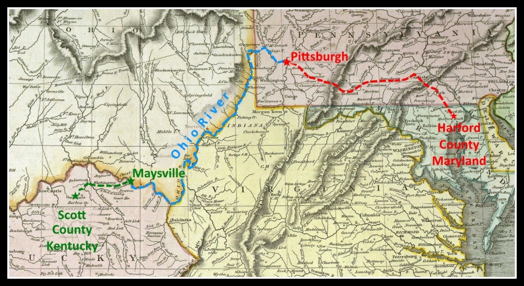
The way west
There were three main routes into Kentucky:
- Overland to Pittsburgh, down the Ohio River, and by land into Northern Kentucky
- Overland to Pittsburgh, down the Ohio River, then up the Licking River or Kentucky River into central Kentucky
- Overland through western Maryland, down the Appalachians to the Cumberland Gap in Tennessee, then by land into central Kentucky
The first route seems most likely for our travelers.
Significant numbers of Marylanders began to migrate to Kentucky after 1775, lured by its rich and plentiful land, but the greatest migration occurred after the Revolutionary War.
This “Maryland League”, and others that followed, went overland to Pittsburgh, then down the Ohio River in flatboats to Maysville, and through the wilderness…
Marylanders to Kentucky 1775-1825
Overland to Pittsburgh
The first leg of the journey was overland to Pittsburgh. There were two routes, both military trails cut before the Revolutionary War. Forbes’ Road, the Pennsylvania Road, was the route from Philadelphia through Harrisburg to Fort Pitt. Braddock’s Road, the Virginia Road, ran from Baltimore northwest through Hagerstown to Fort Pitt.

The route is almost identical today, following some of those old roadways.

William and Margaret Jarvis and their traveling party used one of these roads on their way west. The roads were passable, but narrow and dangerous in the mountain passes.
The distance was more than 250 miles.
They probably used a guide that was familiar with the route, and likely traveled in a group with other settlers.

As they had to pack over the mountains on horse-back, they could carry but little more than their clothing, beds & cooking utensils. As deer, bear, and turkies were plenty, they were supplied with meat by hunting; their cloth was homemade, some dressed in deerskins; many yards of linen were made of nettles: their bread was made by pounding corn in a hommony bloc[k]. Coffee and tea were not used. At that time there were no store goods west of Laurel hill; all articles they could not make themselves, were packed over the mountains from Hagarstown, a distance of 130 miles.
Spencer Records’ Memoir of the Ohio Valley Frontier 1766-1795
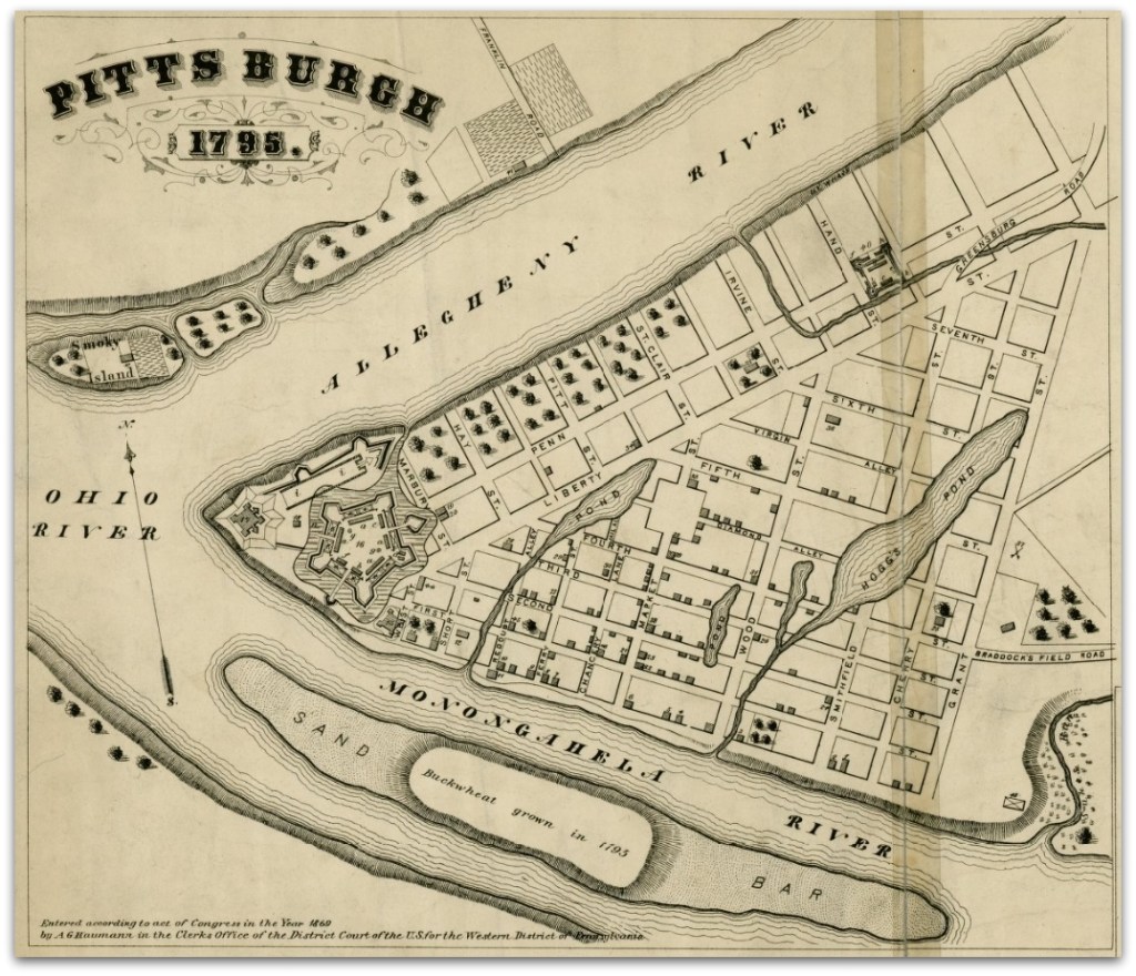
On arriving at Pittsburgh, the weary travelers could rest and re-provision. By the early 1790s, a village had grown up around Fort Pitt, and its strategic location provided opportunities for trading and commerce.
Down the Ohio
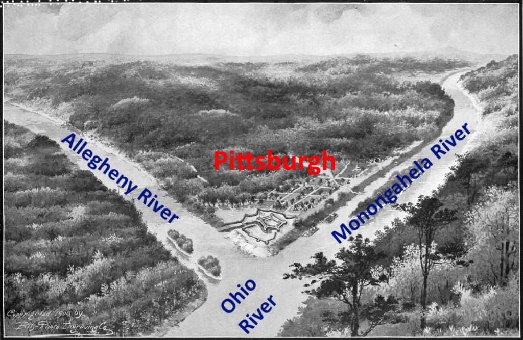
Pittsburgh is situated at the confluence of the Allegheny and Monongahela Rivers, joining to become the mighty Ohio River.
A village had grown up around the military Fort Pitt. By the time William and Margaret arrived in the early 1790s, the population of Pittsburgh was more than 1,000.
One of Pittsburgh’s earliest industries was boat building. Commerce for trade goods between Pittsburgh and the Mississippi River was growing rapidly. And there was an ever-increasing demand to move families into Kentucky and the Ohio Valley. Pittsburgh boat builders were turning out flatboats, barges, and keel boats.
…during a part of the autumn of 1785 an average of eight boats passed Fort Harmar weekly, all bound for Kentucky. By 1787 this average had increased to ten.
…the boats then descending the Ohio carried other cargo than passengers, most moving families being accompanied by horses, cattle, sheep, hogs, farming implements, and household and kitchen goods – by everything, in fact, necessary to begin life anew in the wilderness.
A History of Transportation in the Ohio Valley

The flatboat, or Kentucky boat, was an ideal and economical vessel to move pioneers and goods downriver. It was a big box, with a strong flat bottom and perpendicular sides. It might be partially covered to shelter the inhabitants from the weather.
Flatboats were carried downriver by the current, and usually didn’t return after descending the river. So the travelers usually had to purchase the boat rather than just paying freightage. At the destination, the lumber would be sold or used for building.
One Kentucky boat convenient for a family, between thirty and forty feet in length, costs from one dollar to one and a quarter per foot, making perhaps thirty-five dollars for a comfortable family boat.
Transportation and Traffic on the Ohio and the Mississippi Before the Steamboat
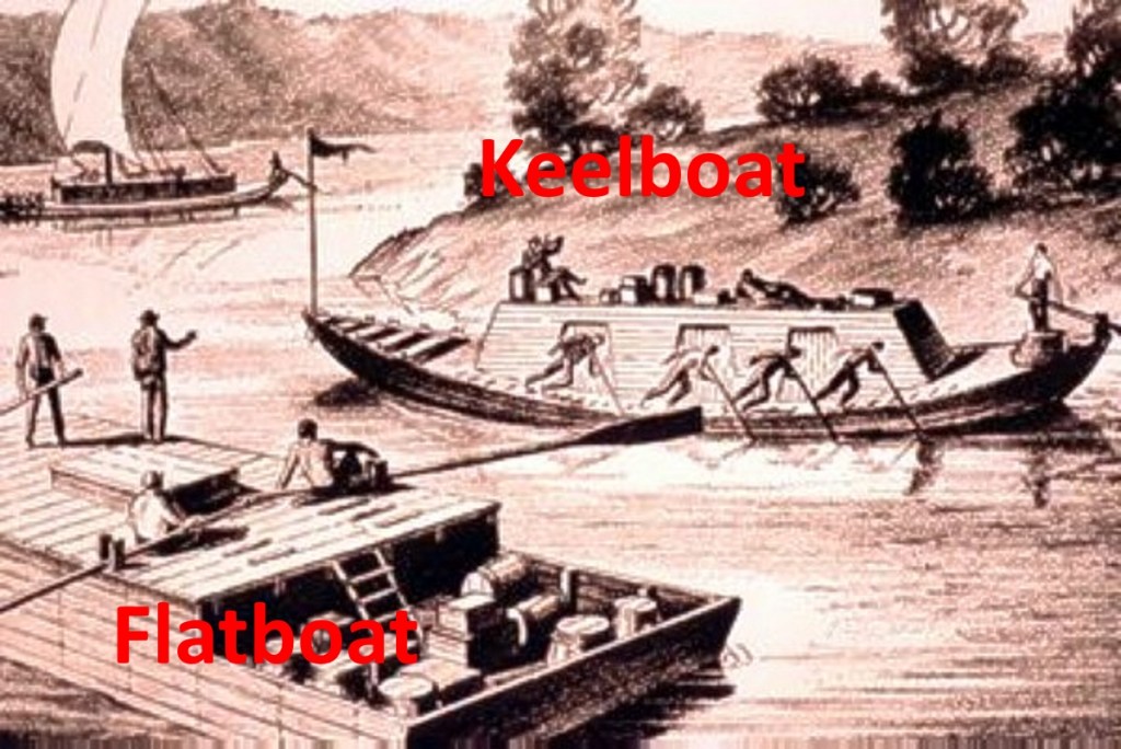
Keelboats were more sophisticated. They could travel upriver, either by “poling” against the current, or towing from the banks by ropes. They required a crew, so were expensive to rent.
Emigrants were usually, at this early period, 1789, detained for several days for a boat to be made ready for their use.
The Ohio River Trade 1788-1830
William and Margaret’s group of travelers arranged a flatboat for their journey down the Ohio River. Their families, animals, and household belongings aboard, the flatboat pushed out into the river.
Once embarked there was no turning back, for upstream navigation in the unwieldy flatboat was next to impossible. The boat rode the current downstream at a speed of six miles an hour.

Long oars, or sweeps, were used to steer. But keeping in the channel of the ever-changing Ohio was challenging. Boats often ran aground on bars, or wrecked on rocks, or were pierced by snagged trees.

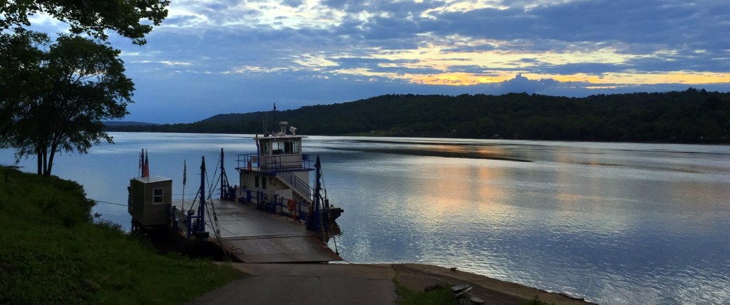
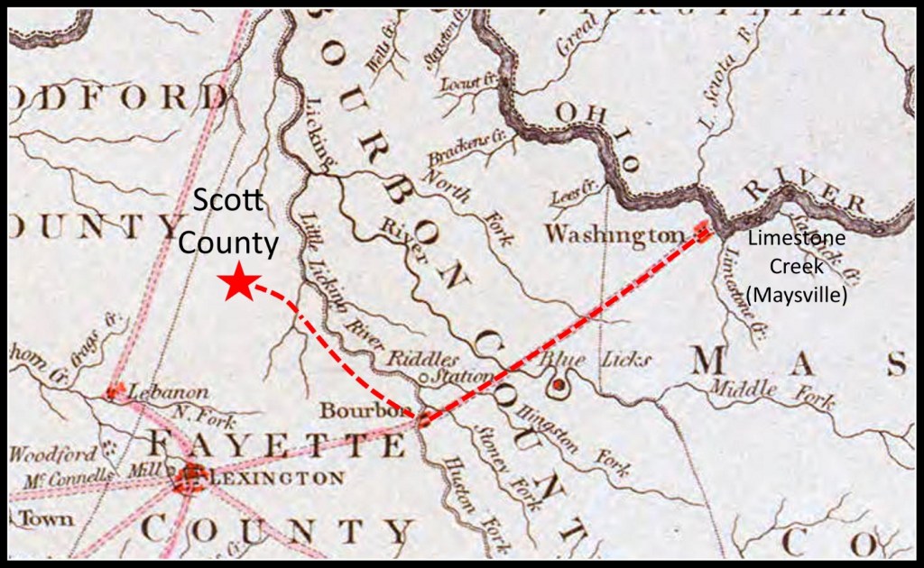
The port towns of Maysville and Cincinnati provided access to northern Kentucky.
The distance from Pittsburgh to Maysville was 392 miles, or to Cincinnati 457 miles. The boaters would often tie up at night. If all went well, the river journey would last less than two weeks.
Landed in Maysville
Our travelers landed at the head of Limestone Creek on the south bank of the river at the settlement of Limestone, recently renamed Maysville.
Here our travelers spent some time selling or disassembling their boat and arranging for wagons.

Frontiersman Simon Kenton made the first settlement here in 1775.
Kenton met new settlers at Limestone, as the landing place was called, and escorted them inland to his station. In 1786 the village which grew up near Kenton’s Station was established by act of the Virginia General Assembly as the town of Washington. By this time, John May had acquired the land at Limestone and Daniel Boone established a trading post and tavern there. In 1787 the little settlement was incorporated as Maysville, though the name Limestone persisted well into the 19th century.
Maysville was still a primitive site of warehouses and wharves, with few dwellings. In 1795, the conclusion of the Northwest Indian War reduced the likelihood of Indian attacks from across the Ohio. Maysville began to flourish.
Maysville, Kentucky – Wikipedia
Ed. Note: Brenda Teply introduced me to Simon Kenton many years ago, in a book about his life and exploits. He was a daring frontiersman and scout. What a surprise to find that our Jarvis ancestors may have crossed paths with him. Check out his dramatic deeds and harrowing escapes: https://en.wikipedia.org/wiki/Simon_Kenton
Daniel, Joshua, and Solomon Jarvis
Maysville is in Mason County, Kentucky. This is where three of William’s cousins settled – Daniel, Joshua, and Solomon Jarvis.
Had they settled here before William and Margaret’s traveling party arrived? If so, perhaps the travelers stayed with the Jarvis cousins a while.
Or had the cousins traveled with William and Margaret, and decided to stay and settle in Mason County? We don’t know.
Into the wilderness
William and Margaret and the Thompsons weren’t settling in Mason County. They were heading further west and were ready to continue their journey.
Kentucky had just begun to be settled. There were no real roads, but there were some Indian trails that had been cut as wagon routes by the military. Once the travelers left the river, it was rough going.
Southwest from Maysville, the road followed the former buffalo trace and Native American trail to Lexington. It was called both the Maysville Road and the Limestone Road. The road was rough and during certain seasons practically impassable.
Maysville, Kentucky – Wikipedia
When we came to the fork of Licking, we found a wagon road cut out, that led up the South fork. This road had been cut by Colonel [Henry] Bird, a British officer, who had ascended Licking in keel boats. They were several days in cutting out this road, which led to Riddle’s fort, which stood on the east side of Licking, three miles below the junction of Hinkston’s and Stoner’s fork.
Spencer Records’ Memoir of the Ohio Valley Frontier 1766-1795
We’re here! Now what?
Our travelers arrived in northern Scott County, twenty-five miles north of Lexington, Kentucky. It had been a long and eventful journey. They had traveled more than 700 miles, over the Appalachians, down the Ohio River, and into the Kentucky wilderness.

Like their parents and grandparents had done, they were starting a new life in wilderness America. It was a long way from Harford County, Maryland.
We don’t know what arrangements they had made for farms or housing, but here they settled.
Sources
- Map – Southern Provinces of the United States, No. 57 in Thomson’s “New General Atlas” – 1817 – Kentucky Historical Society – https://kyhistory.com/digital/collection/Maps/id/81/rec/19
- Marylanders to Kentucky 1775-1825 – Henry C. Peden Jr.
- Map – A MAP OF THE UNITED STATES exhibiting post roads & distances – 1796 – Abraham Bradley Jr
- HISTORIC HIGHWAYS OF AMERICA – VOLUME 5 – The Old Glade (Forbes’s) Road (PENNSYLVANIA STATE ROAD) – Archer Butler Hulbert – https://www.gutenberg.org/files/41118/41118-h/41118-h.htm
- SPENCER RECORDS, OHIO VALLEY FRONTIER 1766-1795 – Spencer Records’ Memoir of the Ohio Valley Frontier 1766-1795 – Contributed by NAOMI MULLENDORE HOUGHAM* – Edited by DONALD F. CARMONY – Reprinted from Indiana Magazine of History Volume LV, December, 1959
- Image of flatboat – Engraving by Alfred Waud – The Historic New Orleans Collection
- Painting – Daniel Boone escorting settlers through the Cumberland Gap, 1851-52 (oil on canvas) by Bingham, George Caleb (1811-79); Washington University, St. Louis, USA; (add.info.: Daniel (1734-1820) and his wife Rebecca travelling westwards to Kentucky)
- Painting – Gateway to the West: Daniel Boone Leading the Settlers Through the Cumberland Gap – 1775 – David Wright, ca. 2000
- Image – Fort Pitt, Pennsylvania, 1759. Captioned: “Fort Pitt and Pittsburgh in 1759, one year after permanent occupation by the English” – Edward White and DeWitt B Lucas – https://commons.wikimedia.org/wiki/File:Fort_Pitt,_Pennsylvania,_1759.jpg
- Map – Pittsburgh 1795 – University of Pittsburgh
- Quotation and Image – Diagram of Coal Flatboat on Licking River – A History of Transportation in the Ohio Valley with special reference to its waterways, trade, and commerce from the earliest period to the present time – CHARLES HENRY AMBLER, Professor of History, West Virginia University
- Image – Flatboat and Keelboat around Pittsburgh – late 18th century – http://www.wqed.org/erc/pghist/photos/PHLFarch/keelflatboats.jpg
- Quotation – cost of a Kentucky boat – Transportation and Traffic on the Ohio and the Mississippi Before the Steamboat – W. Wallace Carson – Source: The Mississippi Valley Historical Review , Jun., 1920, Vol. 7, No. 1 (Jun., 1920)
- Quotation – travelers waiting in Pittsburgh while a boat was prepared – The Ohio River Trade 1788-1830 – Hazel Yearsley Shaw – 1907
- Image – Traveling by Flatboat – Engraving by Alfred R Waud
- Photos of Ohio River – Mark Jarvis – May 2017
- Painting – View of Fort Harmar from the Virginia Side, Marietta, Ohio, ca. 1835 – Charles Sullivan – Oil on canvas. 20″ x 28″. (Courtesy, Peter Tillou Works of Art.)
- Map of the State of Kentucky and adjoining States – J. Russell – 1794
- Quotes about Maysville, Kentucky – Maysville, Kentucky – Wikipedia – https://en.wikipedia.org/wiki/Maysville,_Kentucky#Early_settlement
- Painting – Kentucky Landscape – 1832 – James Pierce Barton – https://commons.wikimedia.org/wiki/File:James_Pierce_Barton_-Kentucky_Landscape-1832-_Google_Art_Project.jpg

The book we read about Simon Kenton was “The Frontiersmen” by Allen Eckert. I’ve read it twice but your very exciting post about your relatives’ move to Kentucky makes me want to read it again. Thanks for the acknowledgement.
LikeLiked by 1 person
Yes, the book was great. But now it’s even greater! Who knew?
LikeLiked by 1 person
What a fascinating description of an incredibly brave journey, Mark. It really brings your
ancestors to life in the imagination. The challenges you describe that they faced were totally terrifying, weren’t they ? I love the illustrations and maps too.
You must be so proud of your forebears’ bravery and determination.
I certainly am – and I’m only descended from their cousins back in England !
Louise.
LikeLiked by 1 person
Thank you Louise. So great to hear from you, and I’m glad you’re concerned and connected with your cousins. We’re all the same family.
Hope we can get together after COVID.
LikeLiked by 1 person
Interesting webpage. I read it over several times before I suddenly remembered that I had some Jarvis in my family tree. I went and looked and sure enough I had Rebecca Jarvis. Rebecca was born in 1760 Harford Co, Maryland and died in 1808 Fleming County , Kentucky. She married James Rigdon, the first cousin of my 7th great grandfather Thomas Rigdon, in 1779 Harford County. Thomas was in the Maryland Continental Line and was sent to the southern US with General/Barron deKalb in 1780 and fought at Camden, Guilford Courthouse and at the Cowpens. After his unit was disbanded in Charlestown, SC in 1783, he settled in Bulloch County, Georgia.
I show Rebecca’s parents as John Jarvis and Hannah Hill. I show that they were both born in Hillshire, England and both died in Maryland but I haven’t checked that closely so it could be wrong. James Rigdon was also from Harford, Maryland and served in the Maryland Flying Camp during the Revolutionary War and then later settled in Fleming county, Ky. In 1832 he gave a deposition in the Fleming county court about his military service. He married 2nd Elizabeth Peachee in 1812 and he died about 1842 in Fleming County.
James Rigdon and Rebecca Jarvis are also the 6th great grandparents of the actor George Cloony, also from Kentucky.
LikeLike
Hi Joe,
Thanks for the comment. Yes, I’ve seen the Rigdon name a lot during my research, especially in Harford County.
“John Jarvis and Hannah Hill” is all over Ancestry, but I haven’t found a credible source. I think it’s incorrect, but…
I found your note about George Clooney very interesting. On one of my Kentucky research trips, I stayed in Augusta, Kentucky. It’s not far from Fleming County. Maybe it was part of Fleming County back in the day. Anyway, in Augusta, there’s the house that’s the birthplace of Rosemary Clooney, mother of George.
Best regards,
Mark
LikeLike
Mark,
Rosemary Clooney is George’s aunt, not his mother. His mother is Nina Warren but yes, she was born in Ky in 1939.
The Rigdons (originally Rigden) are one of the oldest families in Maryland and once lived on Spes Utia when it was still an island and one of only three Hundreds in Maryland. The Rigdens are named in the Will of Capt Richard Ladd in Calvert county in 1691. The Rigdons appear frequently in Harford County records, in fact if you search for “Rigdon farm Maryland” you’ll see that some of the family is still there and quite well known. Col Alexander Rigdon, was the older brother of my GGGG GF Thomas was very active in the associations that plotted the Rev War and was the author of numerous historical documents. Rev John Rigdon who west to Ohio and eventually to Oregon is a first cousin and so is Sidney S Rigdon, the early Mormon. (Their fathers had moved to Pennsylvania and they were born there.) Robert Rigdon is considered to be the first American police officer killed in the line of duty after he was murdered in Baltimore in 1858. You can’t turn over a history book of that part of Maryland without finding a Rigdon!
I will go back and look at what I have for Rebecca Jarvis’ father and send you a copies or some links. I know there is at least one very thoroughly researched paper on the family. It or something similar used to be posted on the website Hackerscreek but that website no longer works.
LikeLike