On July 12, 1813, William and Margaret bought the 100 acre farm from Samuel McMillan. The price was 20 pounds.
William and Margaret Jarvis had been living on their rented farm for 8 or 10 years or longer. So had their neighbors. In 1813, it seems like Samuel McMillan wanted to sell those farms.
William and Margaret bought

This indenture made this 12th day of July in the year one thousand eight hundred and thirteen between Samuel McMillan of Harrison County and State of Kentucky of the first part and William Jarvis of Pendleton County and State aforesaid of the other part, Witnesseth that the said McMillan for and in consideration of the sum of Twenty pounds to him in hand…
… grant, bargain and sell, and confirm by special warranty unto said Jarvis One hundred acres of land in Pendleton County out of Moody’s Survey lying being, and Situate on Fork Lick Creek, a branch of the south fork of Licking, and bounded as follows, Viz:…
The neighbors bought too
On the same day, July 12, at least five of the Jarvis neighbors also bought their farms from Samuel McMillan.
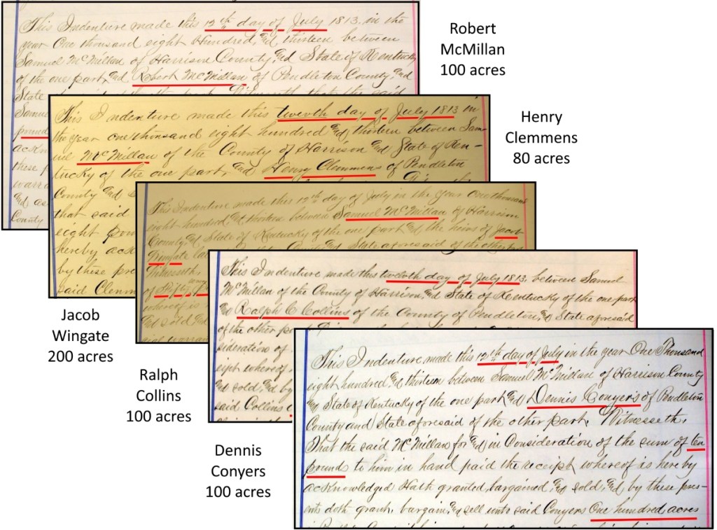
Like the Jarvises, all these neighbors had been living on these same farms for many years, renting from Samuel McMillan. Now, as of July 12, 1813, they all purchased their farms.
It seems like McMillan wanted to convert the farms from rentals to sales. He was getting along in age. Perhaps he was getting his finances in order.
In support of this theory, we find that in 1819 John Hazelwood and Sarah Jarvis Hazelwood bought a nearby farm from the heirs of Samuel McMillan. So McMillan had died sometime between 1813 and 1819.
Fork Lick Creek
All the deeds referenced Moody’s Survey, and Fork Lick Creek.
“…in Pendleton County out of Moody’s Survey lying being, Situate on Fork Lick Creek, a branch of the south fork of the Licking, and bounded as follows, viz:…”
And then each deed continued with a description of its own “metes and bounds”, the old-time way of describing a parcel of land.
From William’s deed:
“Beginning at two sugar trees, and dogwood thence east 200 poles to three large white oak thence north 80 poles to three black oak saplings thence west 200 poles to two white oaks and black oak in Conyers line thence south with the said line 80 poles to the beginning.”
OK, let’s see what that looks like:

OK, we can see that it’s a nice rectangular parcel, but where the heck is it located? We have one hint; that the west line is common with Dennis Conyers land.

Fine. But where the heck is it located? Looking at the other neighbors’ deeds, we see that Jarvis’ south line is common with Jacob Wingate’s north line.
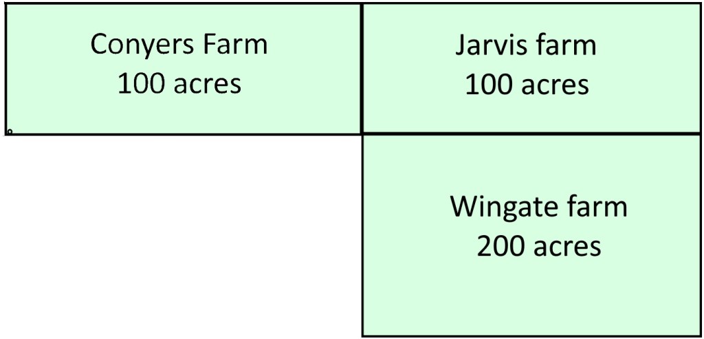
Our luck ran out. None of the other neighbor deeds have a common property line. But they must be nearby. And they’re all on Fork Lick Creek. Maybe we can find it somewhere along the creek.
Here’s an 1884 map of the Callensville precinct in southern Pendleton County. It shows Fork Lick Creek. In 1820, Grant County was created from the west half of Pendleton County, so this 1884 map shows both counties. The Jarvis farm could be in either county in this map.

Our deeds are 70 years earlier than this map, but maybe we can glean something. Looking at the farmers’ names on the maps, we recognize a few – Thompson, Dance, Robinson, and Hume. But none that help us locate the Jarvis farm.
Grant County Library to the rescue
The location of these lands on the waters of Fork Lick Creek had puzzled me for several years.
Determined to find them, I stopped by Pendleton County, Kentucky on my way home from a Maryland research trip, with the express goal of locating the Jarvis and Conyers 1813 farms.
I spent some time in Grant County, as it was partitioned from the western part of Pendleton County in 1820. I hadn’t been to Grant County before.
On genealogy trips, Sundays are for libraries, because court houses and historical societies aren’t open. I was spending a pleasant Sunday at the Grant County Library. They had a small genealogy and history section, and I was browsing the shelves. The librarian asked if I’d like to see some maps and map books that were too large to fit on the shelves. Of course.
Eureka! The Atlas of Grant County Kentucky 1858, by Thomas H. Hutzelman, 1998. Hutzelman spent several years abstracting and plotting the deed descriptions and then computer generating the deed plots for Grant County. Luckily, he also plotted a few properties that were overlapping or adjacent to Grant County in Pendleton County. And there on Plate 26 is Dennis Conyers’ farm.

Beautiful. Jas Moody to Saml McMillan to Dennis Conyers, 12 Jul 1813. The land is just east of the Grant County / Pendleton County line. And there’s Fork Lick Creek.
From our earlier deed description of the common Jarvis line, it’s easy to plot the William Jarvis farm. And from Plate 26, we can locate other neighbors.

Hutzelman comments on the deeds on this Plate 26:
Deeds in the northeast part of this map were scarce. They may have been recorded in Pendleton County, or the area just may not have been heavily settled by 1858.
In 1858, much of this tract was still not sold to settlers, it being full of steep hills and hollows.
The Atlas of Grant County Kentucky 1858, by Thomas H. Hutzelman, 1998
Here’s where the farms are located on a modern map.

Here’s the location of the farms overlaid on a map of the counties, and on a topographic map.
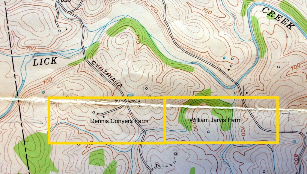
You’ve heard me say that the plots are nice tidy rectangles on a map. But in reality, they’re woods and hills and steep valleys and creeks. The topo map shows the hills and valleys and creeks. Conyers farm is mostly cleared of timber today, but Jarvis farm isn’t. I imagine these farms were very difficult.
Great. Now that we know where they are, let’s go visit.
The farms today

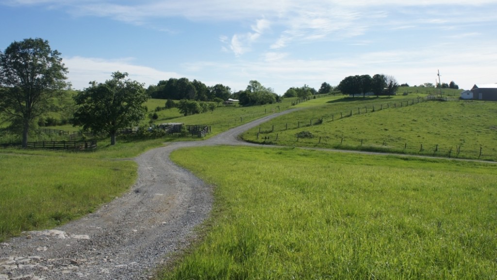
View of Jarvis farm – looking east from Conyers farm 
Conyers farm – looking northeast from top of hill 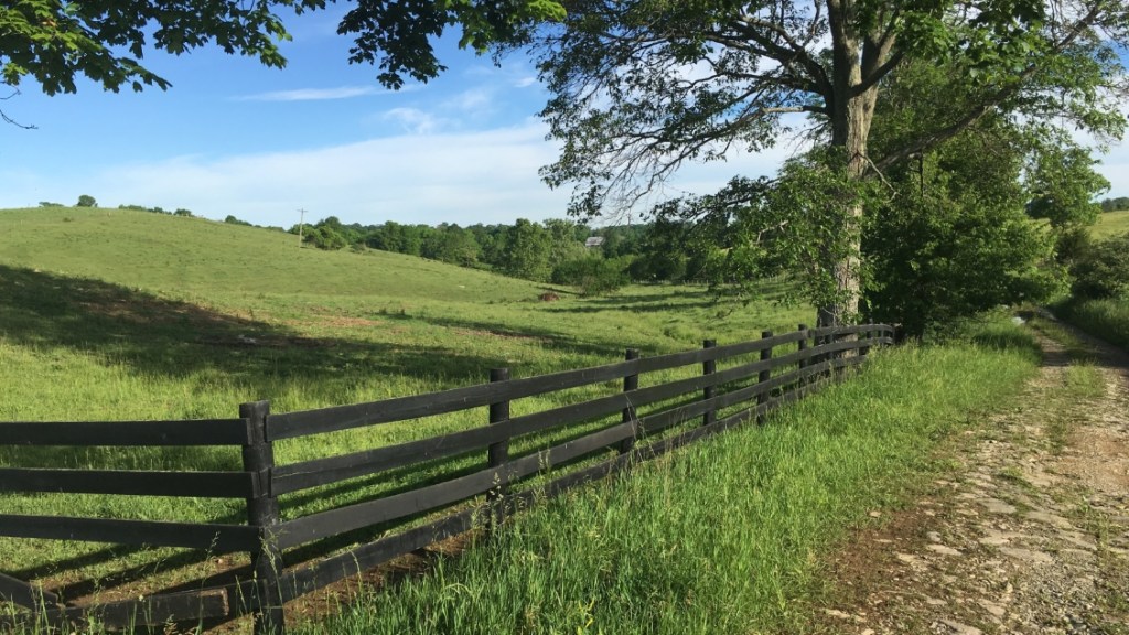
Conyers farm – looking north from center 
Conyers farm – Old Cynthiana Road 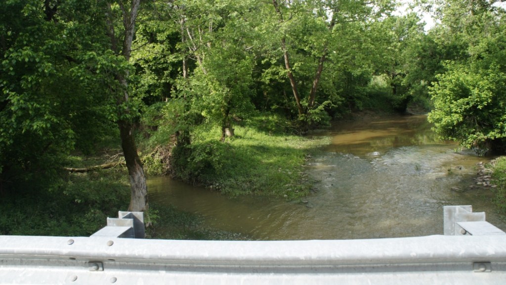
Fork Lick Creek – north side of Jarvis farm 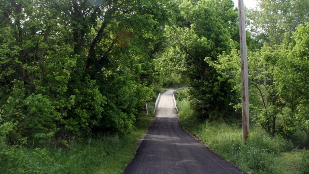
Bridge over Fork Lick Creek – north side of Jarvis farm 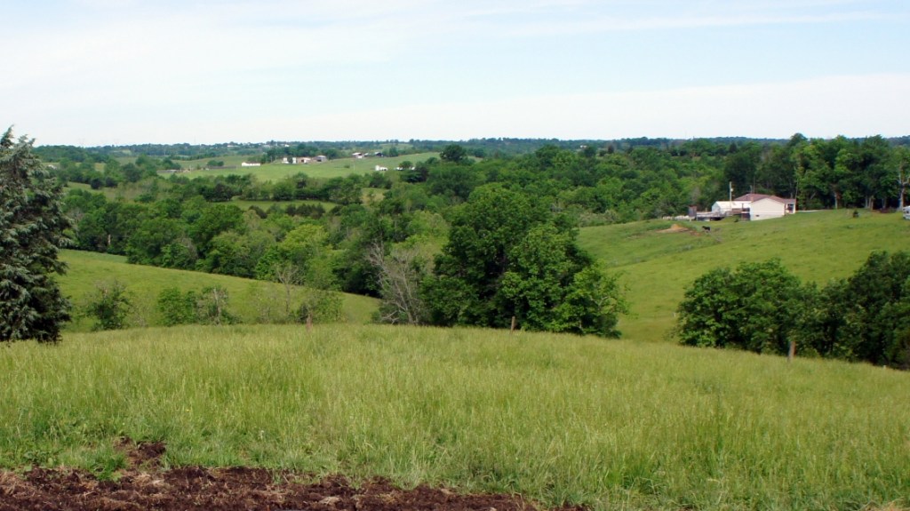
View of Jarvis and Conyers farms – looking northwest 
View of Conyers farm

Sources
- Moody’s Survey – Fayette County Kentucky Land Survey – Book B, Page 75
- Quotations – Early History of Pendleton County – July 4, 1876 – reprinted in Falmouth Newspaper – 1924
- Quotations – When Falmouth Was a Babe in Swaddling Clothes – Dr. H. C. Clark – transcribed by Nancy Bray with permission from The Pendleton County Historical and Genealogical Society
- Quotations – The Settlement of Pendleton County – Mildred Bowen Belew – The First Two Hundred Years of Pendleton County
- The Atlas of Grant County Kentucky 1858 – Thomas H. Hutzelman – 1998 – Grant County Library, Williamstown, Kentucky
- Composite maps – Google Maps 2020
- Composite 1884 Maps of Grant and Pendleton Counties and Callensville Precinct – An Atlas of Bracken and Pendleton Counties, KY – From surveys by J. M. Lathrop and J. H. Summers – D.J. Lake and Co. – 1884
- Topographic Map – Berry Quadrangle Kentucky – US Geological Survey – 1953
- Photos of Jarvis and Conyers farms – Mark Jarvis – May 2017

Great pics of the Kentucky farmland. Reminds me of my relatives’ farms—both sides of the family. As kids we spent many days of summer vacation visiting cousins in rural Ohio.
LikeLike
Yes, looks idyllic now. Thanks.
LikeLike