
When William and Margaret arrived in Kentucky, there were almost no roads.
There were buffalo traces, Native American trails, and a few military cut roads.
The old routes
In 1790s Scott County, and later Pendleton County, there were three routes north to the Ohio River and Cincinnati:
- The Licking River, north from Falmouth, by flatboat or barge.
- Bird’s War Road, through Morgan, just west of Falmouth, then north and south
- The Dry Ridge, a north-south route on hilltops through Williamstown with no water crossings

Licking River was the principal water outlet for Pendleton County in the early days. And for a long time, that stream was crossed by fording with horses and oxen, or ferrying on flat boats.
Many of the roads followed the old Indian trails, up the steep hills, to ridges, from which the riders of horses had better points of observation.
After Fifty Years – Rev. Joel Buell Shomaker – The Falmouth Outlook – September 9, 1932
For long distances this pioneer trace followed the great drainage divide-Dry Ridge-between the waters of Licking on the east and the springs falling into Elkhorn and Eagle Creeks, tributaries of the Kentucky River, on the west.
A Sketch: General Clark and Buffalo Trails, Indian and Pioneer Warpaths near Morgan, KY., Covington, and Cincinnati – Ewing O. Cossaboom
Everyone wanted roads
As Kentucky got settled, everyone wanted a road. In Pendleton County, there was no way to travel east and west. Getting from the Jarvis farm on Fork Lick Creek to the county seat of Falmouth meant fording creeks, crossing hills, and trekking through thick woods. It probably took six or seven hours to travel the 15 miles.
Who made the roads?

The first roads in Pendelton County were marked out and surveyed by people appointed by the courts. Then the people living along those routes would help build and maintain them, by grading and knapping rock to pave them. The creeks in those days didn’t have bridges, they were all forded.
The Settlement of Pendleton County – Mildred Bowen Belew
The residents and courts were very aggressive in planning roads. The earliest court records in Pendleton County are dominated by orders and reports for roads.
Ordering a road
Once the path of a new road was approved, the court assigned residents living within a mile of the roadway to work on its construction.

In this July 1808 court record, the court appointed Thomas Dance surveyor of a road from McClenachan’s ford at Crooked Creek to Owens road, and assigns the hands to work on it, according to law: William Jarvis, John Roberts, William Dehart, Zachariah Robinson, William Elder, Jacob Wingate, Dennis Conyers, John Jump, John Zinn, and John Dance.
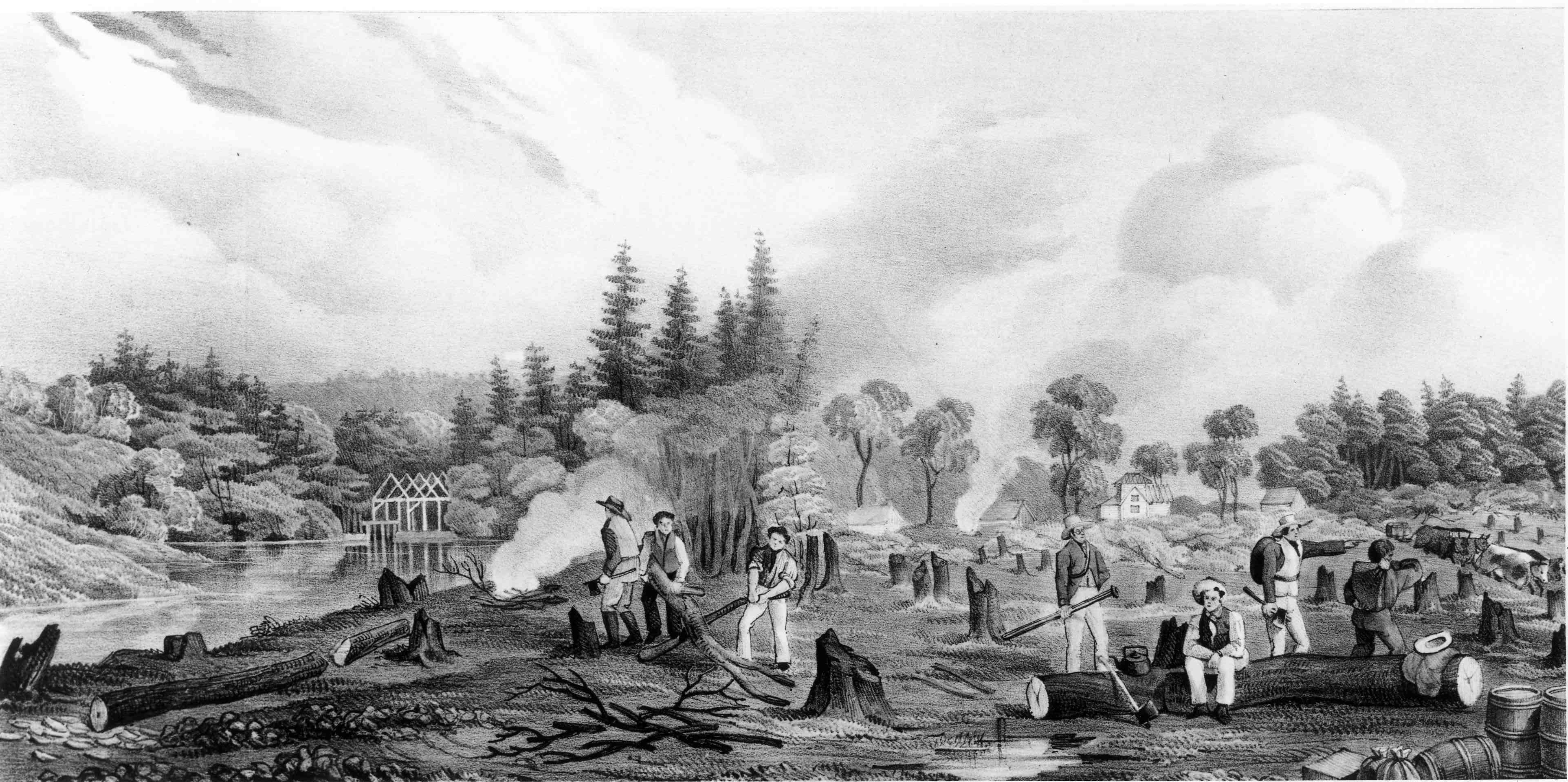
Cutting the road
Road work wasn’t easy. Residents were expected to devote one day per week to road work.
The roads were to be cut 15 feet wide. Where the road passed through thick woods, that meant dozens or hundreds of trees to fell and stumps to pull or burn.

There were no bridges. Where a road needed to cross a creek, the surveyor looked for a shallow part of the creek to ford.
Often the roads took years to complete. Workers would die or move away. Some wouldn’t devote time and were punished by the court. Sometimes the work didn’t progress.
The road was finished
Maybe the road work was complete, but the roads were still very primitive.
Fifty years ago the roads of Pendleton County were not the best highways in Kentucky. Some of the roads were almost impassable during the Winter months, even for horseback riding, and that was the way most people traveled in those days. Visitors from other parts of Pendleton and Campbell Counties often referred to the road from Falmouth to Williamstown as “Muddy Lane”, or some other name not quite so easy to speak.
After Fifty Years – Rev. Joel Buell Shomaker – The Falmouth Outlook – September 9, 1932

Here’s an account by John Palmer, a traveler along the Dry Ridge road in 1818.

19th July, Saturday. This morning we found the road very intricate, being little more than a horse-path crossed by numerous others, the track of wheels being hid in the grass. After some time, we found the road more difficult, trees crossing the narrow path, and every indication of having lost our way, however we kept the only path we could see, till we observed a log-house, situate in a fine vale, about half a mile to our right, and embosomed in the surrounding forest. I dismounted, and went to enquire our route; the farmer directed me, but expecting, or as he said, suspecting, we should go wrong, he obligingly came after us, kept along with our horses some time, and at parting, directed us to ride about a furlong up the stony bed of a shallow creek, and then take the right side, and bear towards the summit till we came to the road, which was about a mile off.
Journal of Travels in the United States – 1818 – John Palmer
Road from William Arnold’s to Dennis Conyers
I’d seen numerous court orders for work on a road from William Arnold’s to Dennis Conyers.
Let’s take a closer look at this road. It’s a case study for the early roads of Pendleton County.
1810 – Dennis Conyers viewed the road
In 1810, the court ordered Dennis Conyers “to view and mark out a road the nearest and best way from William Arnold to Dennis Conyers.” In June, Conyers reported that he had done so.

To “view” the road meant to select a route. To “mark” the road meant to denote landmarks along the viewed route.
1810 – The court orders the road
In August 1810, the court ordered that the road be established as viewed and reported.
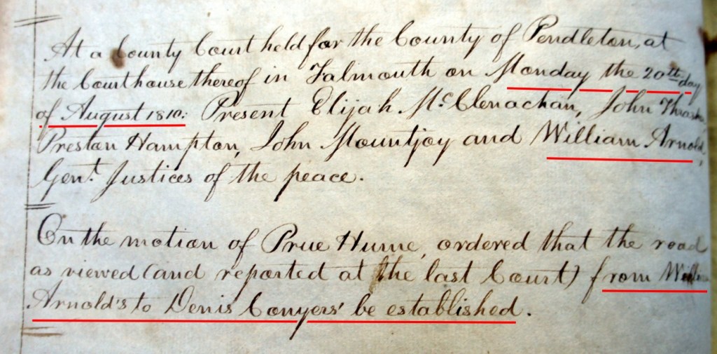
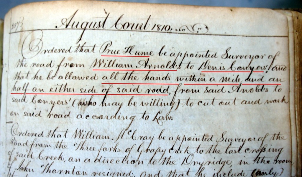
At the same August 1810 session, the court appointed Prue Hume as surveyor of the road from William Arnold’s to Dennis Conyers and allowed Hume all the hands within a mile and a half on either side of the road.
1810 – Assigned hands
At the next month’s court, in September 1810, the court assigned the following hands to work on the road – William Arnold, David Norton, Dennis Conyers, Thomas Hawkins, Zachariah B Godman, and John Arnold.

1813 – William Jarvis surveyor
In August 1813, the court assigned William Jarvis as surveyor of the road, replacing Prue Hume. Work had been underway for three years.

The court allowed the following hands – John Crowder, William Jarvis, John Hazlewood, Dennis Conyers, John Zinn, Ralph Collins, Thomas Hawkins, Zedock Hawkins, David Norton, William Fugate, Joseph Mazingo, William Arnold, and John Fugate.
We can recognize most of these neighbors’ names. They’ve been in several of our previous stories.
1814 – Workers assigned to William Jarvis
Another year and a half passed. The December 1814 court assigns workers to William Jarvis for work on the road. They are William Cooper, John Conyers, William Conyers (husband of Elizabeth Jarvis Conyers).

1817 – Jarvis replaced by Hawkins
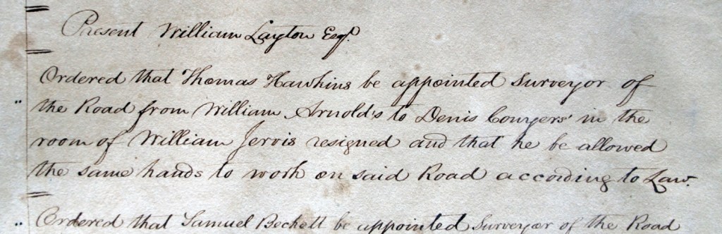
Seven years after the road was ordered, and four years after he was appointed surveyor, William Jarvis resigned. The court “Ordered that Thomas Hawkins be appointed surveyor of the Road from William Arnold’s to Dennis Conyers in the room of William Jarvis resigned and that he be allowed the same hands to work on said road according to law.“
William Jarvis was getting along in years. In 1817, he was 57. Maybe the work was too arduous. Or maybe he figured he’d given four years and that was his fair share.
1821 – Jesse Conyers is surveyor, Harvey Jarvis worker
By 1821, Jesse Conyers, one of Dennis’ sons, was appointed surveyor in place of Thomas Hawkins, who was now in Grant County by virtue of the new county’s creation from the west part of Pendleton County in 1820.

But Harvey Jarvis (4G) was still in Pendleton County, and he was assigned to work on the road along with other neighbors. Harvey was age 18.
The road had been ordered 11 years earlier. Presumably, it was nearing completion. We see some map markings that date the road to 1820 and 1822.

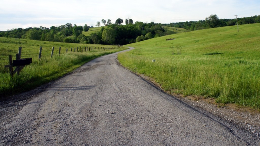
The road today
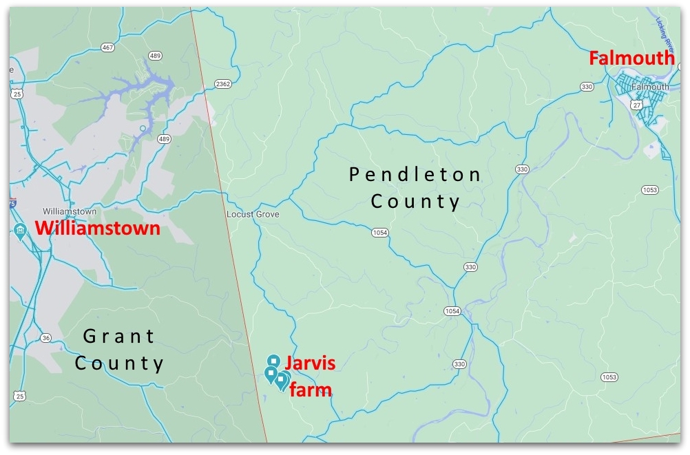
One of my visits to Kentucky included a visit to Grant County. Since Grant County was formed from the west half of Pendleton County in 1820, I wanted to see what I could find there.
You recall my “Eureka” find at the Grant County Library, where I found the location of Dennis Conyers’ and William Jarvis’ farms. Well, Grant County had another gift awaiting me.

The courthouse and library are in Williamstown, the county seat. And what’s next door to the courthouse? The house of William Arnold!

William Arnold is the “William” in “Williamstown”. Duh! Sometimes it’s right in front of you in plain view, but you don’t see it.
William Arnold moved to Kentucky in 1783. He was a prominent citizen, becoming a Justice of the Peace in Pendleton County.
Arnold was one of the founders of Grant County, and he was the first sheriff. He donated land for the town of Williamstown, his namesake.
Let’s find the road
Now we know the location of Dennis Conyers farm, and we know the location of William Arnold’s house. So now we can investigate the road between the two.
The road they laid out is the Cynthiana Road (Old Cynthiana Road), much of which is still in use today.

The road today runs from Williamstown to the north bank of Fork Lick Creek, just north of Conyers farm. The road continues about a half mile south of the creek.
The road today doesn’t ford the creek. There’s another road a mile east, John Denny Road, that has a bridge over Fork Lick Creek.
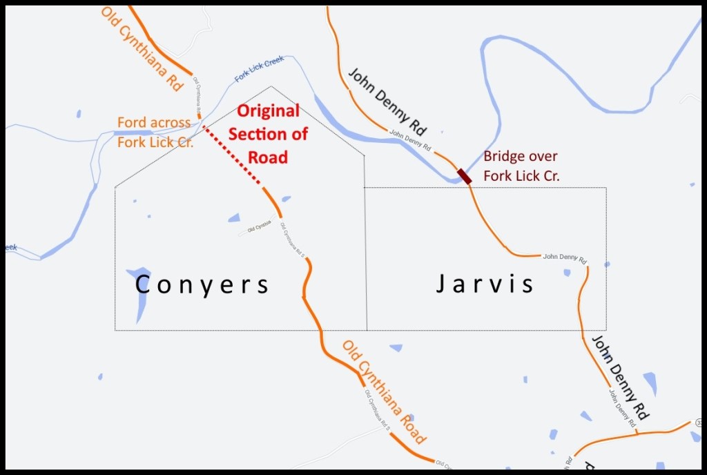
Today, you can use the road from Williamstown to the north side of the creek. And you can use the road on the south side of the creek. But the road doesn’t ford the creek nowadays.
That leaves a half mile of the old road unused – from the middle of Conyers farm to the south bank of Fork Lick Creek. This part of the road must be just like it was years ago. Maybe it’s just as William Jarvis and his neighbors constructed it.


The roads today
Over time, roads were cut throughout Pendleton and Grant Counties. Many of today’s roads follow those original 1800s road routes.
Today, there’s hardly a straight stretch of road in the two counties.
Sources
- Image – Old Indian Trail – Sleeping Bear Dunes National Seashore – https://commons.wikimedia.org/wiki/File:Old_Indian_Trail_(9968949746).jpg
- Photos of Old Cynthiana Road and William Arnold house – Mark Jarvis – May 2017
- Quotation about the Dry Ridge – A SKETCH: GENERAL CLARK AND BUFFALO TRAILS, INDIAN AND PIONEER WARPATHS NEAR MORGAN, KY., COVINGTON and CINCINNATI – Revised 1978 by Ewing O. Cossaboom. Copied from the Falmouth Outlook, 1984 – Pendleton County Historical & Genealogical Society News Letters – Volume II, Issue IV, December 1995 – Volume III, Issue I, March 1996 – Transcribed with permission by Bonnie Snow
- Quotations about early routes – Licking River and Indian trails – After Fifty Years – Rev. Joel Buell Shomaker – The Falmouth Outlook – September 9, 1932
- Image – Clearing trees – Clearing the Town Plot at Stanley, October 1834 – W.P. Kay, – NA, C-40780 – https://history.earthsci.carleton.ca/company/history/images/Clearing_Stanley_lg.jpg
- Quotations – Journal of Travels in the United States of North America and Lower Canada Performed in the Year 1817 – John Palmer – 1818 – https://www.google.com/books/edition/Journal_of_Travels_in_the_United_States/X60TAAAAYAAJ?hl=en&gbpv=1
- Quotations about courts ordering roads – The Settlement of Pendleton County – Mildred Bowen Belew – The First Two Hundred Years of Pendleton County
- Quotation about condition of roads – After Fifty Years – Rev. Joel Buell Shomaker – The Falmouth Outlook – September 9, 1932
- Quotations – Kentucky’s Story – KET Education – https://education.ket.org/resources/kentuckys-story/#historical-background-life-on-the-kentucky-frontier-17501820
- Image – Illustration from The Circuit Rider: A Tale of the Heroic Age by Edward Eggleston depicting a Methodist circuit rider on horseback – Edward Egglestone – 1906 – https://commons.wikimedia.org/wiki/File:Circuit_rider_illustration_Eggleston.png
- Image – Muddy road – Roads in the 18th Century – John Hearfield – 2012 – http://www.johnhearfield.com/History/Roads.htm
- The Atlas of Grant County Kentucky 1858 – Thomas H. Hutzelman – 1998 – Grant County Library, Williamstown, Kentucky
- Composite maps – Google Maps 2020
- Composite 1884 Maps of Grant and Pendleton Counties and Callensville Precinct – An Atlas of Bracken and Pendleton Counties, KY – From surveys by J. M. Lathrop and J. H. Summers – D.J. Lake and Co. – 1884

.jpg)