Indiana had become an agricultural and commercial success, with a population over 1.3 million. Like other northern states, Indiana’s interests and politics were at odds with the southern states.
By 1860, things were at a turning point.
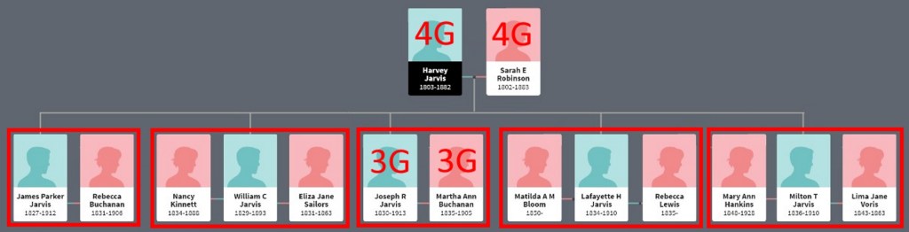
Harvey and Sarah Jarvis
In 1860, Harvey and Sarah (4G) were living in the household of Johnson and Elizabeth Watts.
Harvey was age 57, Sarah 58. Harvey’s occupation is listed as stone mason.

None of their children were living with them, as they were all grown and living within a few miles of Cross Plains.
Johnson and Elizabeth Watts
The Watts were a prominent family in Dearborn County. Johnson Watts was a state senator, signed the Indiana constitution, and had numerous business enterprises.

WATTS, Johnson. HOUSE, 1826-27 (DEARBORN); SENATE, 1837-38, 1838-39, 1839-40, 1840-41, 1841-42, 1842-43 (DEARBORN). (Son of John Watts, brother of John Sebree Watts, qq.v.) Born July 7,1794, Bryant’s Station, Fayette County, Kentucky. Attended common schools. Married Elizabeth McClain, 1814 (8 children)-died; married Mary Lewis, 1867 (2 children). War of 1812: Kentucky militia. Indiana militia: 3rd Regimen, lieutenant colonel, 1820. Moved to Dearborn County, Indiana, in 1816; and to Patriot, Switzerland County, ca. 1868. Farmer; tanner; distiller; storekeeper; flatboat trader. Whig; Republican. Justice of the peace in Dearborn County, 1817-20; member, Constitutional Convention, 1850-51. Lost for state senator, 1833; lost for U.S. House of Representatives, 1851. Freemason. Died May 27, 1871, Patriot, Switzerland County, Indiana.
A Biographical Directory of the Indiana General Assembly, 1816-1899 – Rebecca A. Shepherd
Watts impressive biography lists several business enterprises – farmer, tanner, distiller, storekeeper, flatboat trader.
If Watts had all the businesses going, he would surely need help running and maintaining them. I’m guessing that Harvey had a role like foreman or manager of some of those efforts.
Near Cross Plains
The Johnson Watts farm was in the very southwest corner of Cesars Creek Township in Dearborn County. It was bounded on three sides by Laughery Creek, the boundary of adjacent Ripley and Ohio counties.
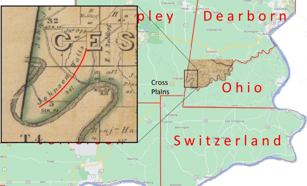
Even though the Watts farm is in Dearborn County, it’s closer to Cross Plains than any town in Dearborn County. It’s just over four miles. It supports the Jarvis adage “All roads lead to Cross Plains”. The roads on the Watts farm that led to Laughery Creek could have been fording points for the trip to Cross Plains.
Joseph and Martha Jarvis
In 1860, Joseph and Martha (3G) were living in Shelby Township, Jefferson County.

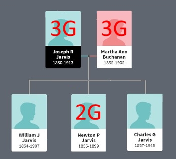
Joseph is age 30, Martha 25. They had three sons so far in their eight years of marriage – William, 6, Newton, 4, and Charles, 2. More children would follow in the 1860s.
In 1859 Joseph and Martha sold the “difficult” farm in northeast Jefferson County to John Risk for $1,200. They had bought that farm from parents Harvey and Sarah in 1852 for $750 just before they married.
Now they were living a few miles west, near Hicks Ridge. They were likely renting a farm.
We’ll use our strategy of finding others that are listed on the same or previous or next page of the census. Using an 1876 map (that’s 16 years later than the census), we can still find many of those neighbors from the 1860 census – Campbell, Thornton, Moody, Buchanan, Vestal, etc.
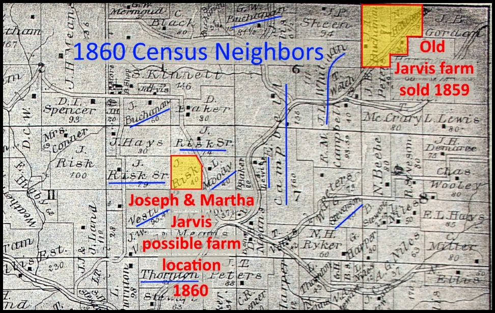
And we’ll peek ahead a few years. We know that Joseph and Martha bought a farm in 1865 that’s marked in yellow on the map. Maybe they were renting and living there in 1860.
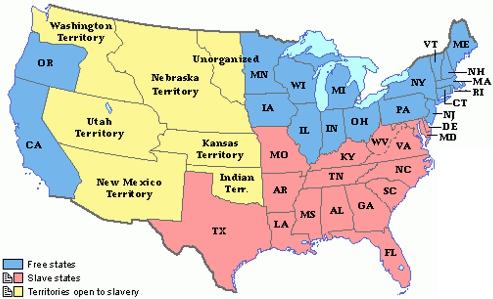
The 1850s politics of slavery
Indiana was predominantly Democratic. Most Hoosiers placed the preservation of the union higher than their views on slavery. In fact, many were against slavery but were prejudiced against blacks.
The 1816 Indiana Constitution forbade slavery. But in 1851, a new constitution was drawn and ratified. It had a clause to exclude all negroes from the state.

In 1851, a vote on Indiana’s new constitution included a separate vote on whether African Americans were to be excluded from the state, and this vote provided a clear measure of Indiana racial attitudes. Most Hoosiers did not want more African Americans in the state.
The Politics of Slavery
87 of 91 counties voted in favor of Article 13, to exclude negros and mulattos from Indiana.
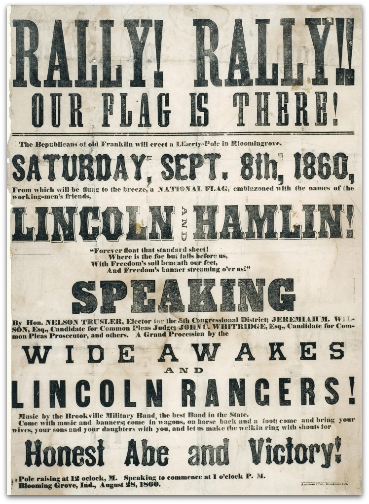
The 1860 presidential campaign

There were four candidates.
The Constitutional Union Party was strongest along the Ohio River; the lanes of commerce connected them to the commercial classes of the South, who were at the core of Bell’s supporters.
The Southern Democrats also showed strength along the Ohio, as well as in some interior counties in which Jesse Bright’s political machinery was still in place.
Douglas and the Northern Democrats retained strength in south-central and southwestern Indiana, at least in those places where the Southern parties did not sap some of their strength.
The real triumph of the Republican Party, however, was to transform much of the central portion of the state from balanced—or even Democratic leaning—to strongly Republican.
The Politics of Slavery

The Republican candidate Abraham Lincoln was the least well-known candidate. But he ran a well-organized campaign, and many of his stump speeches and debates were published in national newspapers.

The election
The 1860 United States presidential election in Indiana took place on November 6, 1860. Indiana voters chose thirteen representatives, or electors, to the Electoral College, who voted for president and vice president.
1860 United States presidential election in Indiana – Wikipedia
The presidential election of 1860 was one of the most consequential in US history.
From voter registration rolls, we can see that Joseph Jarvis voted in the election. We don’t know how he voted.
The election result…
Despite minimal support in the South (Lincoln’s name was not on the ballot in 10 Southern states), he won a plurality of the popular vote (40%) and a majority of the electoral vote.
1860 United States presidential election – Wikipedia

In Indiana, Lincoln won by a large margin – 51% to Douglas’ 42%.

… and dark clouds of secession
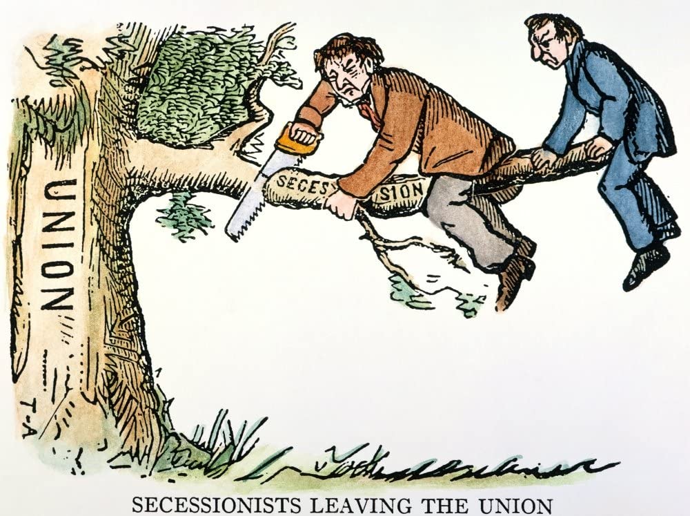
The election of Lincoln led to the secession of seven states in the South before the inauguration and the outright secession of four more (plus the partial secession of two others) once the Civil War began with the Battle of Fort Sumter.
1860 United States presidential election – Wikipedia
Timeline 1860s

Sources
- 1860 Census – Harvey and Sarah Jarvis – Cesar Creek Township, Dearborn County, Indiana – Ancestry.com
- A History of Freemasonry in Indiana from 1806 to 1898 – Daniel McDonald – 1898 – http://webapp1.dlib.indiana.edu/inauthors/view?docId=VAC1123&brand=ia-books
- Quote on bio of Johnson Watts – A Biographical Directory of the Indiana General Assembly, 1816-1899 – Rebecca A. Shepherd
- Quote on business enterprises of Johnson Watts – “History of Dearborn and Ohio Counties, Indiana: from their earliest settlement: containing a history of the counties, their cities, townships, towns, villages, schools, and churches, reminiscences, extracts, etc., local statistics, portraits of early settlers and prominent men, biographies, preliminary chapters on the history of the Northwest Territory, the state of Indiana, and the Indians.” (Chicago: F.E. Weakley & Co., 1885)
- 1860 Census – Joseph and Martha Jarvis – Shelby Township, Jefferson County, Indiana – Ancestry.com
- Quotation and image about 1851 Indiana Constitution – The Politics of Slavery – Richard Nation – Indiana Historical Bureau – https://www.in.gov/history/3995.htm
- Image of historical marker about 1851 Indiana Constitution – Indiana Historical Bureau – https://www.in.gov/history/markers/4107.htm
- Image – 1860 Election Poster – Politico – https://www.politico.com/story/2012/08/party-conventions-aura-of-unity-079158
- Image – 1860 Election Debate Poster – Politics and Lincoln’s Relationship with Indiana – Friends of the Lincoln Collection – https://www.friendsofthelincolncollection.org/lincoln-lore/politics-and-lincolns-relationship-with-indiana/
- Image – Stump Speaking – George Caleb Bingham – St. Louis Art Museum – https://www.slam.org/collection/objects/29774/
- Image – The County Election – George Caleb Bingham – St. Louis Art Museum – https://www.slam.org/collection/objects/29775/
- Quotation and chart about results of 1860 election – Wikipedia – 1860 United States presidential election in Indiana – Wikipedia – https://en.wikipedia.org/wiki/1860_United_States_presidential_election_in_Indiana
- Quotation about results of 1860 election – 1860 United States presidential election – Wikipedia – https://en.wikipedia.org/wiki/1860_United_States_presidential_election
- Image – Secessionist cartoon – Slideplayer.com – https://slideplayer.com/slide/12339932/
- Map – 1860 Free-Slave States – Grolier Online – http://go.grolier.com/atlas?id=mh00120
