Let’s search for Patrick Gallagher’s parents in County Donegal.
Not much to go on
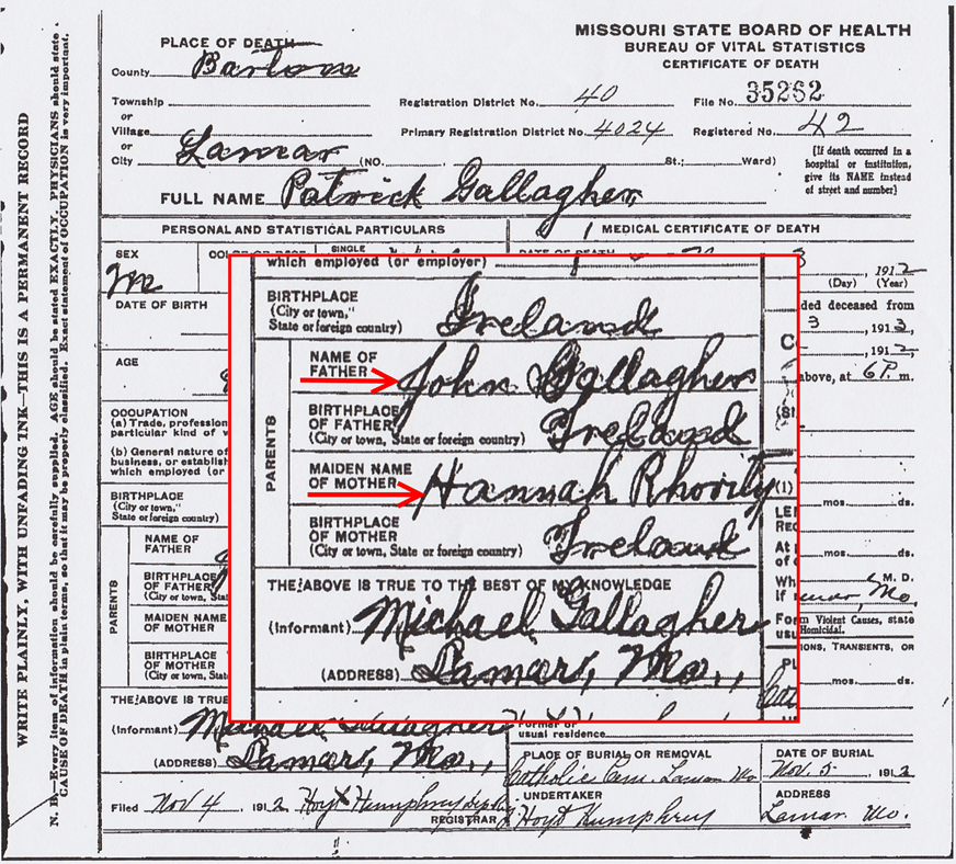
We know the names of Patrick Gallagher’s parents – John Gallagher and Hannah Rhoorty. We know their approximate birth years and marriage year. We know Patrick had a brother Michael. We know they lived in County Donegal.
A difficult search
As we’ve learned, many early records were destroyed in the Four Courts fire. Census records don’t exist for 1821-1851. That’s exactly the period we need. Patrick Gallagher was born in 1827 and emigrated around 1850.
And we don’t have Tom Gallagher’s letter describing his visit, or any other citations in our family documents.
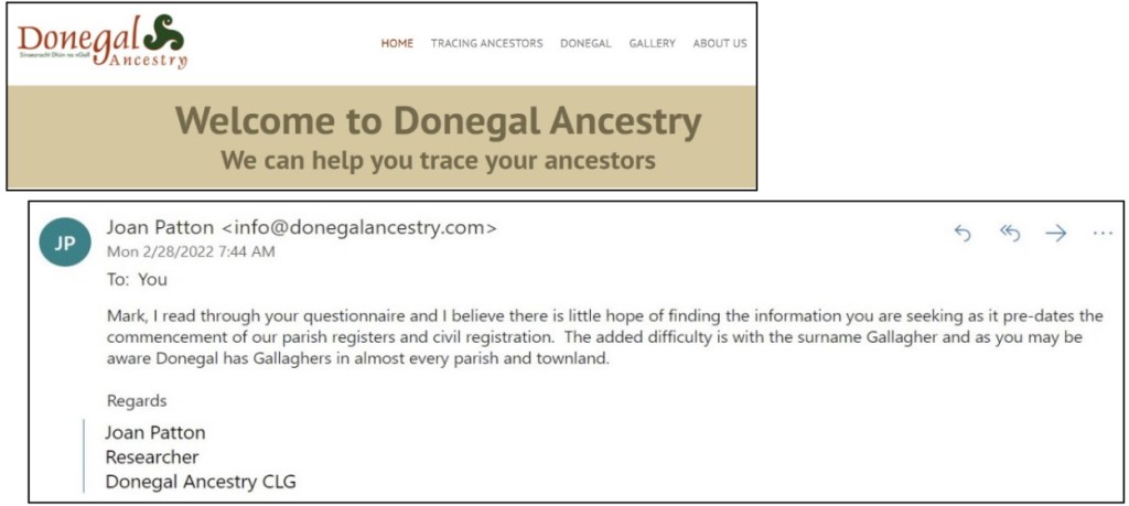
Expert Help
I booked a research assessment with Donegal Ancestry. But my hopes were dashed.
OK. Let’s try anyway. We’ll do the best we can.
Some records are available
In the absence of conventional research sources, Irish genealogists scour tithe records and land valuation records.
To understand these records, we need to find out about land divisions and place names.
Irish Land Divisions
Here’s the land division hierarchy:
- County
- Barony
- Parish (civil)
- Townland
County Donegal consists of 8 baronies, 53 civil parishes, and 2,711 townlands.
We’re most interested in Parish and Townland divisions. Let’s look at an example of each.
A parish example
Donegal is divided into 53 parishes. Let’s look at the Parish of Tullaghobegley. It’s a parish along the northwest coast. It’s about 10 miles square.
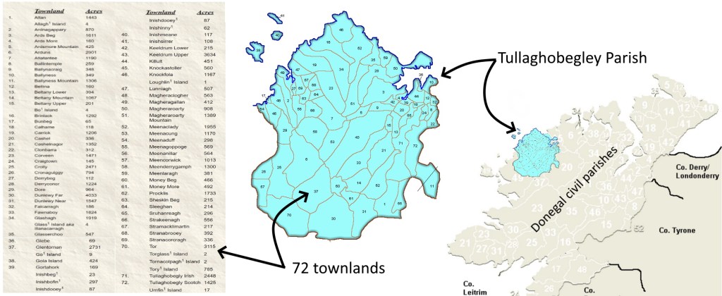
A townland example
Tullaghobegley Parish is divided into 72 townlands. If you can read the small print, you can see that the townlands range in size from a few dozen acres to over a thousand, averaging perhaps 500 acres. So each townland is rather small.
Let’s look at the Magheraclogher townland. It’s one of the 72 townlands in Tullaghobegley Parish. It’s on the west coast, and consists of 688 acres, about one square mile.

Place names
These land divisions date from medieval times. And each has a “place name,” a name with meaning.
A townland might be named for its physical characteristics, like hill, rock, stream, or valley. Or it could be named for its founding family. Magheraclogher means “a plain of stones.”

Irish place names are important, and they’re fun.
For example,
- Ballycormack (baile = town) is town of Cormack.
- Loughmuck (loch = lake + muc = pig) is Pig Lake
- Closnkeagh (cluain = meadow + sceach = hawthorn) is Hawthorn meadow

Tithe Applotment and Griffith’s Valuation
OK, now we know about land divisions and place names. Let’s begin our search for John and Hannah. We’ll turn to the Tithe Applotments and Griffith’s Valuation.
Because of the destruction of early 19th-century census returns, the Tithe Applotment Books of c.1823-38 and Griffith’s Valuation, dating from 1847 to 1864, have acquired a somewhat unnatural importance.
Irish Place Names – JohnGrenham.com
The Tithe Applotment Books
Prior to 1823, tithes were paid “in kind”, with crops or animals or food. In 1823 a law was passed that required tithes to be paid in cash. The tithes were paid to the Protestant Church of Ireland, which was the state church of Great Britain. This tithe to the church was in addition to the rents paid to the estate landlords.
The Tithe Applotment Book project (1823-1837) was to appraise agricultural holdings to set the tithe amount. Tithe assessment was unfair, assessing tithes on arable land like peasant farms, while assessing no tithe on pasture land that would be controlled by landlords. The Tithe Applotment Books are organized by county, parish, and townland.
The tithes were resisted by many, especially Catholics and Presbyterians. Many refused to pay, and Tithe Wars broke out in the early 1830s.
The tithe project is not a census. It lists only those who hold land, not those with jobs or trades. The project lists only the landholder, not the family members. This project was done before The Great Famine, so before mass emigration and death decimated the population.
Even so, the books represent the earliest records for the poor in Ireland, a group for whom very few other genealogical records survive from this period.
In fact, if your ancestors lived in one of the rural parishes for which no pre-1850 church registers exist, Tithe Applotment Books may also be the only documented records of their lives.
Tithe Applotment Books – Irish Genealogy Toolkit
In spite of shortcomings, the Tithe Applotment Books are just the years we’re interested in – 1823 to 1837. Patrick Gallagher was born in 1827. His parents John Gallagher and Hannah Rhoorty probably married around 1820. So it’s possible that John Gallagher was listed in the tithe books.
A Tithe Applotment example 1830
Here’s an example of the Tithe Applotment Book. It shows that several Gallaghers had small farms in the Magheraclogher townland in 1830. Recall that Magheraclogher was 688 acres, about one section of land.

In Magheraclogher, there were 47 landholders registered. 10 were Gallaghers. 2 were John Gallagher. One of these John Gallaghers could be our ancestor, the husband of Hannah and father of Patrick.
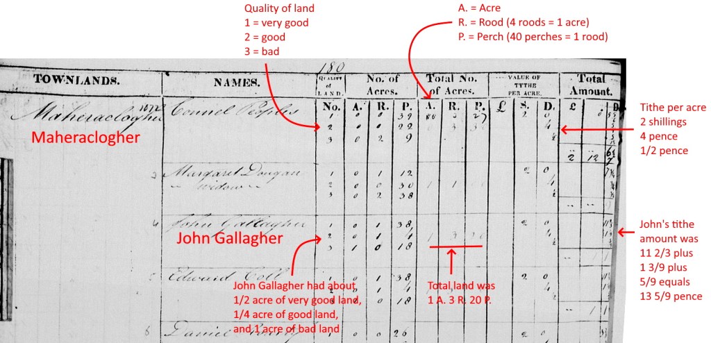
This John Gallagher had 1 acre of bad land and 3/4 acre of good and very good land. He owed 13 pence in tithes to the protestant Church of Ireland, even if he was a Catholic. John probably didn’t like that.
Griffith’s Valuation
Griffith’s Valuation took place a generation later than the Tithe Applotment project. This 1840s-1860s project was an attempt to map and value each property to assess the tax value. Richard Griffith was the Commissioner of Valuation. His teams produced this monumental work. It mapped and listed and valued every property in Ireland, except multi-tenement buildings in the cities.
Every building and every field in the country was assessed in meticulous detail to produce a monetary figure that represented the income that property should produce every year. The results were published between 1847 and 1864 in a series of 301 volumes.
How to date Griffith’s Valuation – John Grenham
Griffith’s Valuation is not a census. It doesn’t list family members. But it’s much more complete than the generation-earlier Tithe Applotment Books. This project was completed after The Great Famine (1845-1852), so there had been mass emigration and death.
A Griffith’s Valuation example 1857
Here’s an example of a Griffith’s Valuation list and map. It shows several Gallaghers’ small farms (1 to 4 acres) in the Townland of Magheraclogher in 1857. It shows their houses, land, and offices (an office means an out-building, like a stable).
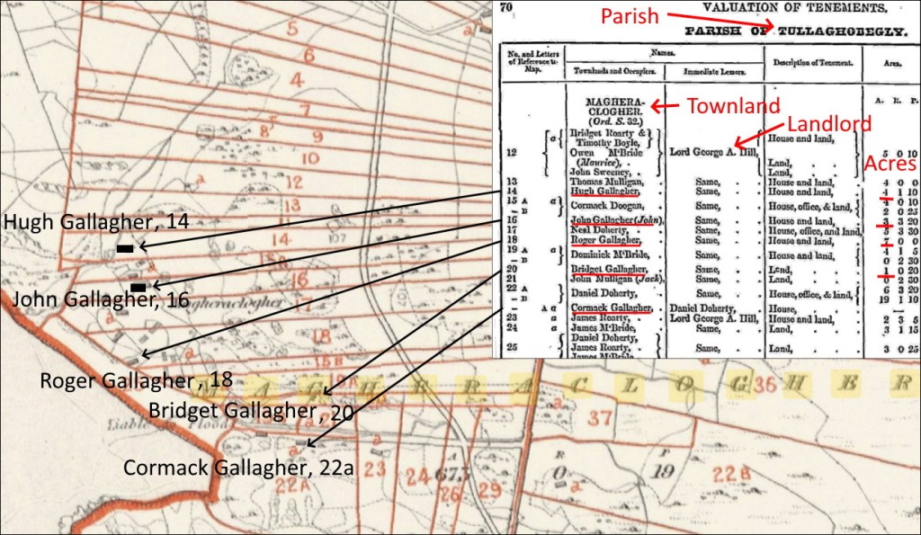
In Magheraclogher, there were 72 landholders registered. 14 were Gallaghers. Many of these are the same people or descendants of those listed 27 years earlier in the Tithe Applotment Books. Is it the same John Gallagher? Is he our ancestor?
Griffith’s Valuation is amazing! We can see the location of a family’s house and farm. We can see relationships between neighbors. We can see the estate owner who collects the rent from all these people.
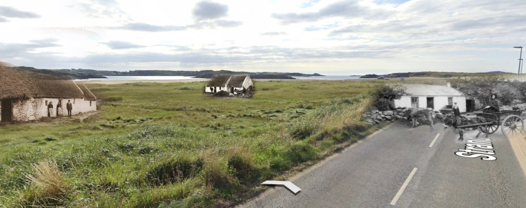
If we plot the 1857 Gallaghers on a Google Earth map today, we can still see the same patterns of fields and houses that exist today. It’s easy to imagine Gallaghers living there today.
If Patrick’s father John Gallagher occupied a house or land in 1850s, he was listed in Griffith’s Valuation. Unfortunately for us, there were dozens of residents named John Gallagher. And Griffith’s listed only the head of household, so we won’t see Hannah’s name or any children. And, unfortunately, John Gallagher may have died by the 1850s. So…
So what?
Great. Irish place names are interesting. I understand parishes and townlands. But, so what?
Why are we looking at Tullaghobegley Parish and Magheraclogher townland? There are hundreds of Gallaghers all over Donegal?
This was a lot of tech talk. Let’s take a break. We’ll continue the search next time.
Sources
- Photo – Irish cottage – Library of Congress – https://www.loc.gov/resource/stereo.1s27809/
- Death certificate – Patrick Gallagher – Lamar, Missouri – 1912 – ancestry.com – https://www.ancestry.com/imageviewer/collections/60382/images/1912_00035440-02878?pId=83906
- Quote – Irish Place Names – John Grenham – https://www.johngrenham.com/browse/retrieve_text.php?text_contentid=65
- Image – Examples of place names – Dublin 1850 – https://www.dublin1850.com/general/placenames.html
- Image – cottage and a plain of stones – Irish Examiner
- Map – Tullaghobegley Parish – rootsweb – http://freepages.rootsweb.com/~bhilchey/genealogy/MTullaghobegley.html
- Tithe Applotment Book examples – The National Archives of Ireland – http://titheapplotmentbooks.nationalarchives.ie/search/tab/home.jsp
- Griffith’s Valuation Table and Maps – askaboutireland.ie – https://griffiths.askaboutireland.ie/gv4/single_layer/i8.php?lat=&longt=&dum=0&sheet=33,42&mysession=2803225493808&info=&place=&county=DONEGAL&placename=BELTANY%20MOUNTAIN&parish=TULLAGHOBEGLY&country=Ireland&union=&barony=KILMACRENAN
- Map video – 360 view of Magheraclogher area with Gallagher house locations – https://earth.google.com/web/search/Magheraclogher,+County+Donegal,+Ireland/@55.06723191,-8.30692115,3.24521022a,500d,35y,5.15846063h,0t,0r/data=CigiJgokCV571bC1O0FAEVt71bC1O0HAGW0viFkI1kJAIU2RbdrcMlPA
- Image – composite of Google Street View and old photos from Library of Congress
- Quote – Tithe Applotment Books – Irish Genealogy Toolkit – https://www.irish-genealogy-toolkit.com/tithe-applotment-books.html
- Music – The Ladies of Leinster – Brendan Bulger – Seamus Connolly Collection – Soundcloud – https://soundcloud.com/connollymusiccollection/the-ladies-of-leinster-reel

Very instructive post, thanks! I am going to share this with my genealogy group. Debbie Fox
LikeLike
Thanks. Glad you found it useful. Pretty geeky for non-genealogists, but it seemed important to understand future posts.
LikeLiked by 1 person