By 1820, several of William and Margaret Jarvis’ adult children had moved their families to Indiana. Where? Why?
Indiana opened to settlement
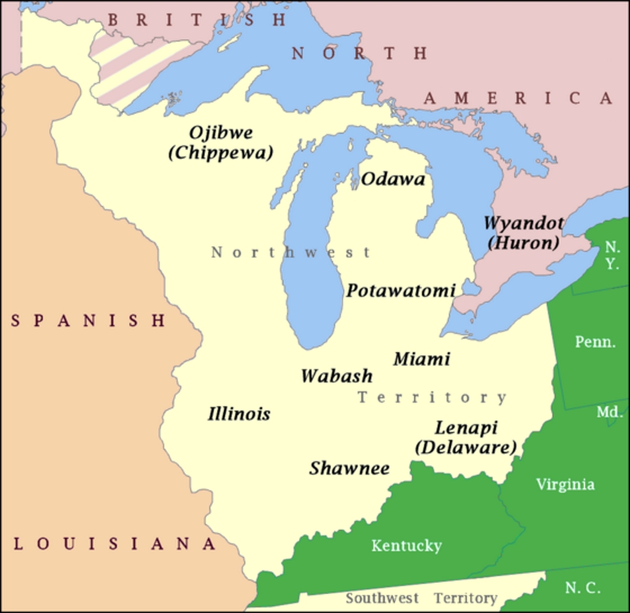
The Northwest Territory was a huge tract of land west of Pennsylvania, north of the Ohio River, and west to the Mississippi. It was the home to Native American tribes. By 1800, encroaching settlement had caused armed conflict. Native American tribes were defeated.

American settlement began before 1800 and increased substantially after the War of 1812, when Native Americans were removed from their lands.
Indiana Emigration and Immigration – Family Search
The Land Act of 1796
An Act providing for the Sale of the Lands of the United States, in the territory northwest of the river Ohio, and above the mouth of Kentucky river…
Land Act of 1796
After the Revolutionary War, Congress was deeply in debt. It used the sale of government lands in the west to generate revenue. The Land Act of 1796 was created to encourage western settlement. The Act was modified over the years to make land acquisition easier and cheaper.
In 1820, the minimum parcel size was reduced to 80 acres, and the minimum price to $1.25 per acre. So a settler could buy a piece of land for $100.
Cheap land was available. Lots of it.

Settlers from the Upland South
Most of Indiana’s early settlers were from the North Carolina Piedmont and the Upland South (Kentucky, North Carolina, Virginia, and Tennessee). These populations usually came to Indiana via the Ohio River or along overland routes.
Settlement of Southern Indiana – Lincoln Boyhood Historic Resource Study
The Jarvises and their neighbors were among those from the Upland South who were the earliest Indiana settlers. They already lived close, within 50 miles of southern Indiana.

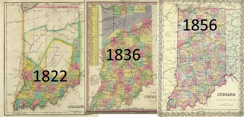
Along the north side of the Ohio River, new counties were being formed. One source said that Indiana filled up like a drinking glass, from bottom to top. When Indiana was admitted as a state in 1816, most of the residents were along the southern boundary.
Jarvises, Conyers, and Robinsons move
By 1820, three of the Jarvis siblings had moved to Indiana. They first settled near Allenville in Switzerland County, just across the Ohio River from Pendleton County, Kentucky.
- James and Mariah Elder Jarvis
- Armit and Malinda Jarvis Robinson
- Joseph and Margaret Jarvis Robinson

After William Jarvis died in 1823, two more Jarvis siblings moved to Indiana, including our grandparents Harvey and Sarah Jarvis.
- Harvey and Sarah Robinson Jarvis (4G)
- William and Elizabeth Jarvis Conyers
By 1830, five of the Jarvis siblings were living in Indiana.
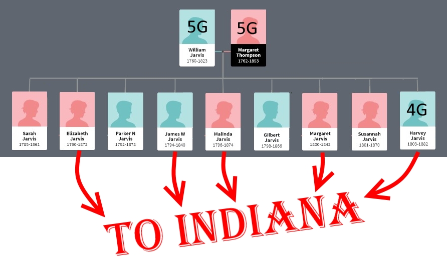
Three of the other four other Jarvis siblings moved away from Pendleton County, but not to Indiana.
- Parker Jarvis moved to Illinois by 1820, then spent his later life in Louisville
- Gilbert moved to Shelby County, Kentucky, just east of Louisville
- Absalom and Susannah Jarvis Robinson moved to central Ohio
John and Sarah Jarvis Hazlewood stayed in Pendleton/Grant County on their farm near William and Margaret’s farm on Fork Lick Creek.
After William Jarvis died in 1823, his wife Margaret moved into the household of her daughter Sarah Jarvis Hazlewood and lived there for many more years. John Hazlewood probably worked the Jarvis farm.
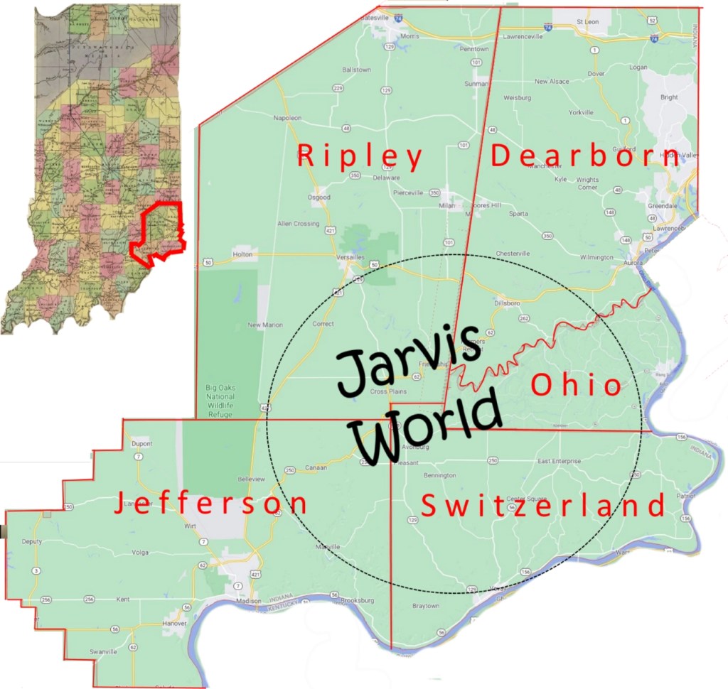
Jarvis world
Those that moved to Indiana built new communities, farmed, worked, and had lots of children. The Jarvis, Conyers, and Robinson families were numerous and well-known.
For the next three generations, our grandparents lived within a 20 mile circle centered on the intersection of five counties – Ripley, Dearborn, Ohio, Switzerland, and Jefferson.
A land patent

By the mid-1820s, some of the Jarvis and Conyers and Robinson settlers got land patents.
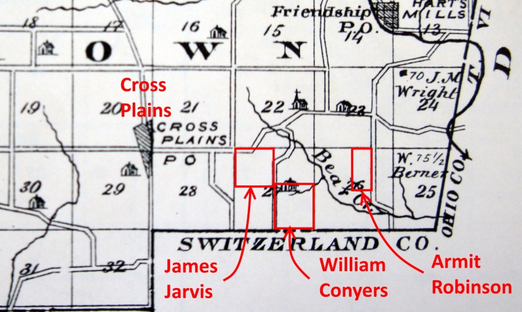
Let’s look at a patent for James Jarvis, Harvey’s older brother.
The 1825 patent refers to “An Act providing for the sale of the Lands of the United States, in the Territory north-west of the Ohio, and above the mouth of the Kentucky River.”
James had acquired 160 acres in the southeast corner of Ripley County, Indiana, just a mile east of the village of Cross Plains.
Armit and Malinda Jarvis Robinson also got a patent near James Jarvis’ land. William Conyers got one too.

Nibbles Extra Credit
PLSS vs. Metes and Bounds
The land description on James Jarvis’ patent is “the Northwest quarter of Section twenty-four, in Township Six (North), Range twelve (East) containing one hundred and sixty acres.”
What’s Section twenty-four? What’s Township Six? What happened to the descriptions that we’re used to seeing, like “Beginning at two sugar trees, and dogwood thence east 200 poles to three large white oak…?”
It’s Metes and Bounds vs. the PLSS.
Metes and Bounds
The system of metes and bounds to describe real estate had been used in the United States and England for centuries.
Here’s the metes and bounds description of William and Margaret Jarvis’ farm in Pendleton County, Kentucky in 1813:
“…in Pendleton County out of Moody’s Survey lying being, Situate on Fork Lick Creek, a branch of the south fork of the Licking, and bounded as follows, viz:… Beginning at two sugar trees, and dogwood thence east 200 poles to three large white oak thence north 80 poles to three black oak saplings thence west 200 poles to two white oaks and black oak in Conyers line thence south with the said line 80 poles to the beginning.”

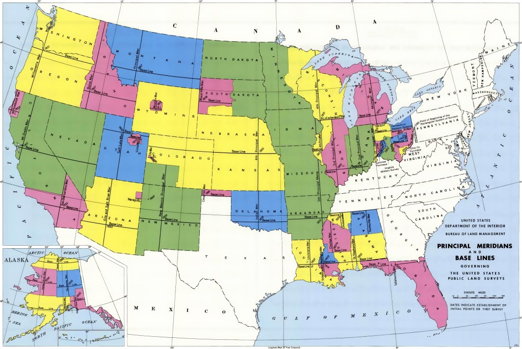
PLSS – Public Land Survey System
The Public Land Surveying System (PLSS) is a way of subdividing and describing land in the United States. Its surveys create townships, sections, etc. It was begun in 1795 to map the vast lands west of the original colonies.
The lands in Ohio and the Northwest Territory were the first in the US to be surveyed and sold using the PLSS.
Using PLSS, there was a standard and accurate way of describing and locating a land parcel. It’s still in use today.

You can read more detail about the PLSS in an earlier blog post SE 1/4 of Section 20 T2S R6E.
What happened to the metes and bounds system?
Surprisingly, the old metes and bounds system wasn’t replaced by PLSS. In fact, there were several other systems that are still in use.
The original colonies obviously didn’t use the PLSS, as it wasn’t yet invented. They still don’t use it.
Texas doesn’t use it. Parts of California and many Indian Reservations don’t use it. Who knew?
Timeline 1820s
Sources
- Image – Advice on the Prairie – National Oregon / California Trail Center – https://oregontrailcenter.org/pioneers-talk
- Map – Northwest Territory – The Northwest Territory, created by the Northwest Ordinances of 1785 and 1787, with the Ohio Company of Associates’ purchase (c. 1787) and township schemes. Encyclopedia Britannica, Inc. – https://www.britannica.com/event/Treaty-of-Greenville
- Map – Northwest Territory – CC BY-SA 3.0 – https://commons.wikimedia.org/w/index.php?curid=1255728
- Quotations about Land Act of 1796 – Library of Congress – https://www.loc.gov/law/help/statutes-at-large/4th-congress/session-1/c4s1ch29.pdf
- Quotations about Indiana settlers – Hoosiers and the American Story – https://indianahistory.org/wp-content/uploads/Hoosiers-and-the-American-Story-ch-03.pdf
- Quotations about Indiana immigration – Indiana Emigration and Immigration – Family Search – https://www.familysearch.org/wiki/en/Indiana_Emigration_and_Immigration
- Quotations about Indiana statehood and Indian removal – History of Indiana – Wikipedia – https://en.wikipedia.org/wiki/History_of_Indiana#Founding
- Quotation about population and settlement – Settlement of Southern Indiana – Lincoln Boyhood Historic Resource Study – https://www.nps.gov/parkhistory/online_books/libo/hrs/hrs5b.htm
- Map Composites – Google Maps 2020, 1822 Geographical, Historical, And Statistical Atlas Map Of Indiana – 1836 A New Atlas Map Of Indiana with its Roads & Distances – 1856 Atlas Map of Indiana – David Rumsey Historical Map Collection – https://www.mapofus.org/indiana/
- Image – Land Patent of James Jarvis – Bureau of Land Management – US Department of Interior – https://glorecords.blm.gov/details/patent/default.aspx?accession=IN0320__.289&docClass=STA&sid=wzmjmvye.qmw
- Image – PLSS organization – Wikipedia https://commons.wikimedia.org/wiki/File:Public_Land_Survey_System.png
- Map – PLSS states – Wikipedia – https://en.wikipedia.org/wiki/Public_Land_Survey_System
- Photos – farmland – Mark Jarvis – July 2017

Hello, cousin! Armit Robinson is my 4th Great Grandfather and I have just come upon your page. I couldn’t help but notice that second time that he is mentioned above, in the land acquisition area of the page, “Margaret” is erroneously typed in place of “Malinda.”
If you are interested in the Descendants from Malinda to me, I can help. Also, my Grandfather (John Morris Robinson, Jr.) wrote a Lineage on The Jarvis Family if there is any information that you care missing on other lines that I might help fill in or lead you on a path you might be looking for, please let me know!
LikeLike
Hi Kimberly. Delighted to hear from you.
Yes, I’m interested! Both in your lineage and your grandfathers Lineage of the Jarvis family. How can you share those with me?
I’ll check out the erroneous “Margaret.” I make mistakes often, and I appreciate readers’ corrections and edits.
I hope you find the stories interesting and useful. There were a lot of Jarvis/Robinson connections!
Mark
Here’s my contact info:
Mark Jarvis
markcjarvis@hotmail.com
LikeLike