Land records are an important source of genealogy information.
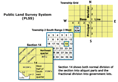
The Public Land Survey System (PLSS) is a way of subdividing and describing land in the United States.
Let’s decode the land description language. Then it will make sense, and we can locate almost any land parcel.
In 1875, Joseph Swoboda bought the homestead claim of Patrick Quigley. Let’s examine the land description.
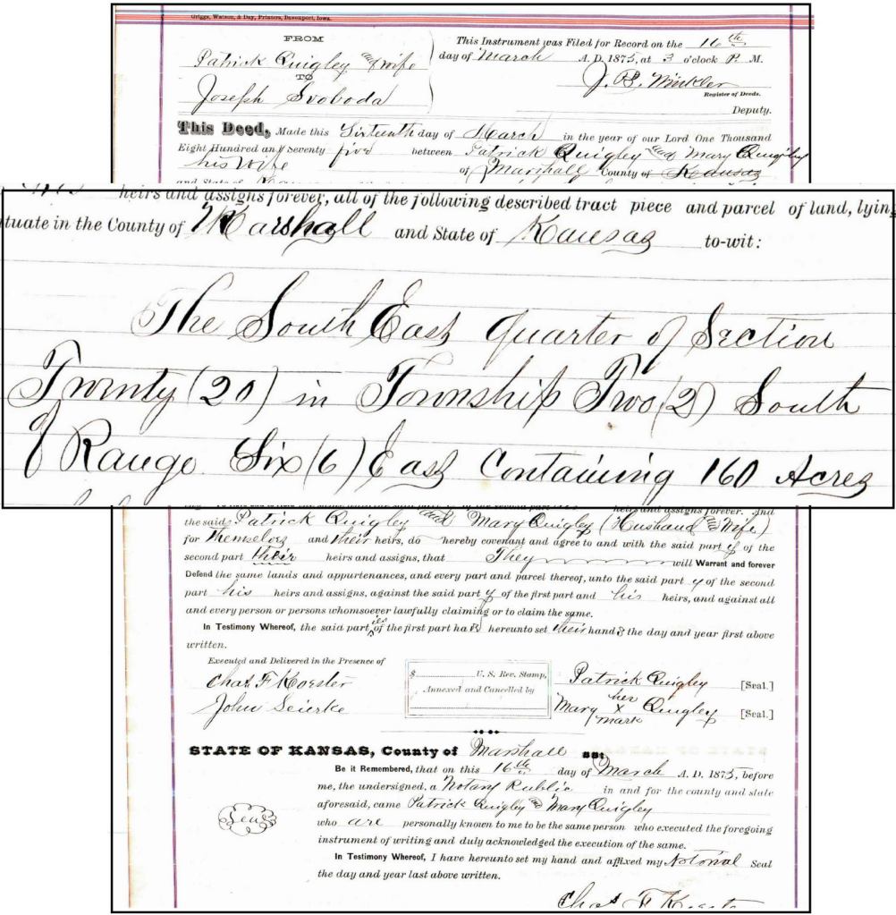
“…in the County of Marshall and State of Kansas to-wit: The Southeast Quarter of Section Twenty (20) in Township Two (2) South, Range Six (6) East containing 160 acres.”
Counties
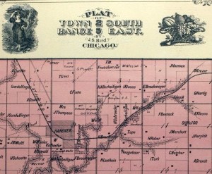
Each state is divided in to counties. Here you can see Washington and Marshall Counties in northeast Kansas.

Townships
Each county is divided into townships.

Townships are normally a square approximately 6 miles (9.7 km) on a side with cardinal boundaries conforming to meridians and parallels, containing thirty-six sections of one square mile each.
ArcGIS
The townships are formally identified by Township (North/South) and Range (East/West).
Here’s a map of Marshall County, Kansas, showing its townships.
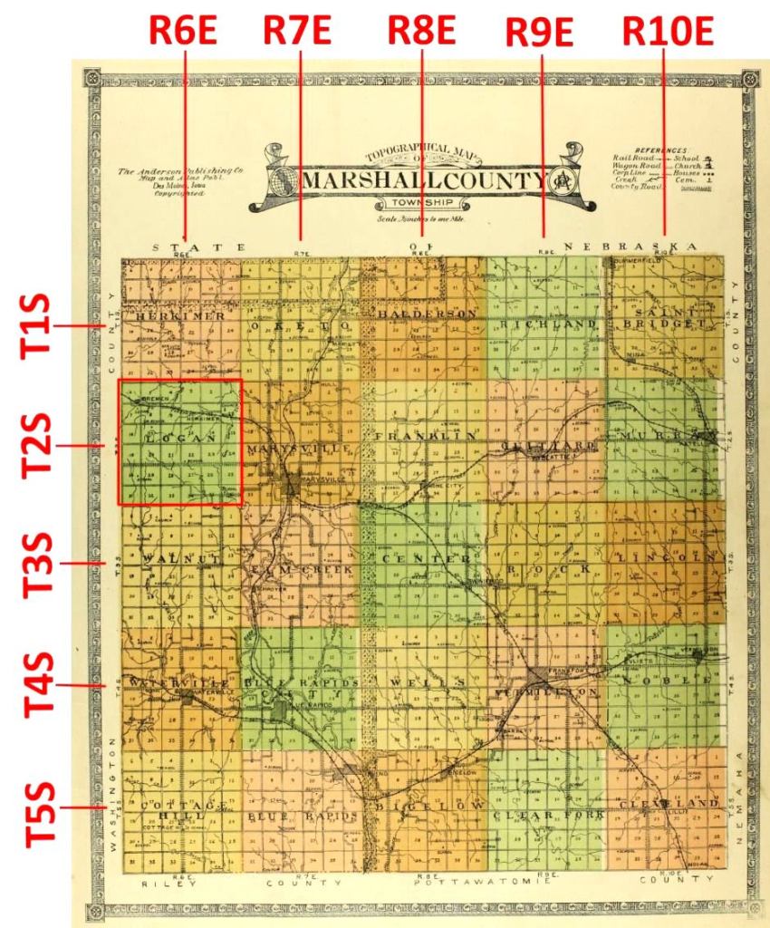
You can see that Logan Township is Township Two South and Range Six East.
The townships also have names. These are arbitrary names, and not used for legal descriptions. But people know the township names, not the ranges. We’re interested in Logan Township in Marshall County.
For Joseph Swoboda’s homestead, we can understand the part “in Township Two (2) South, Range Six (6) East.” That’s Logan Township.
Sections
Each township is dividied into sections. A section is one square mile. In other words, a square measuring one mile on each side.
And each section is numbered within its township: 1, 2, 3, etc.
Here’s a map of Logan Township, Marshall County. You can see the numbered sections.
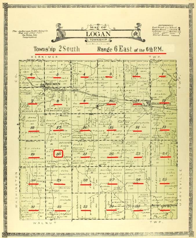
For Joseph Swoboda’s homestead, we can understand the part “of Section Twenty (20).” That means his land is in the Section numbered 20.
Each section contains 640 acres.
Halfs and Quarters
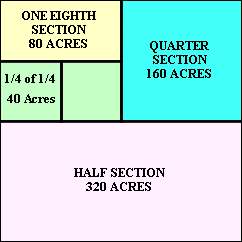
Each parcel of land within a section can be described by fractions, like half or quarter.
On the map, you can see Section 20 outlined in yellow. And the SE Quarter, outlined in red.
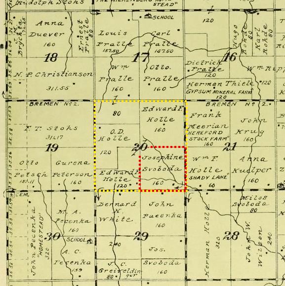
For Joseph Swoboda’s farm, we can understand “the SouthEast Quarter of Section 20 (20).”
This is a 1922 map. It shows Josephine Svoboda as owner, because Joseph died earlier in 1904.
Find these fractional parcels:
- the SE Quarter of Section 20 (Josephine Svoboda)
- the West Half of Section 30 (John Pecenka)
- the N Half of the NE Quarter of Section 28 (Milos Svoboda)
- the SE 1/4 and the S 1/2 of the NE 1/4 of Section 28. (John Wilson)
Since each section has 640 acres, a quarter section has 160 acres. It’s noted on Swoboda’s parcel. 160 acres was the size of a homestead claim.
Put it all together
Now when you see a land parcel description, it won’t be intimidating.
“…in the County of Marshall and State of Kansas to-wit: The Southeast Quarter of Section Twenty (20) in Township Two (2) South, Range Six (6) East containing 160 acres.”
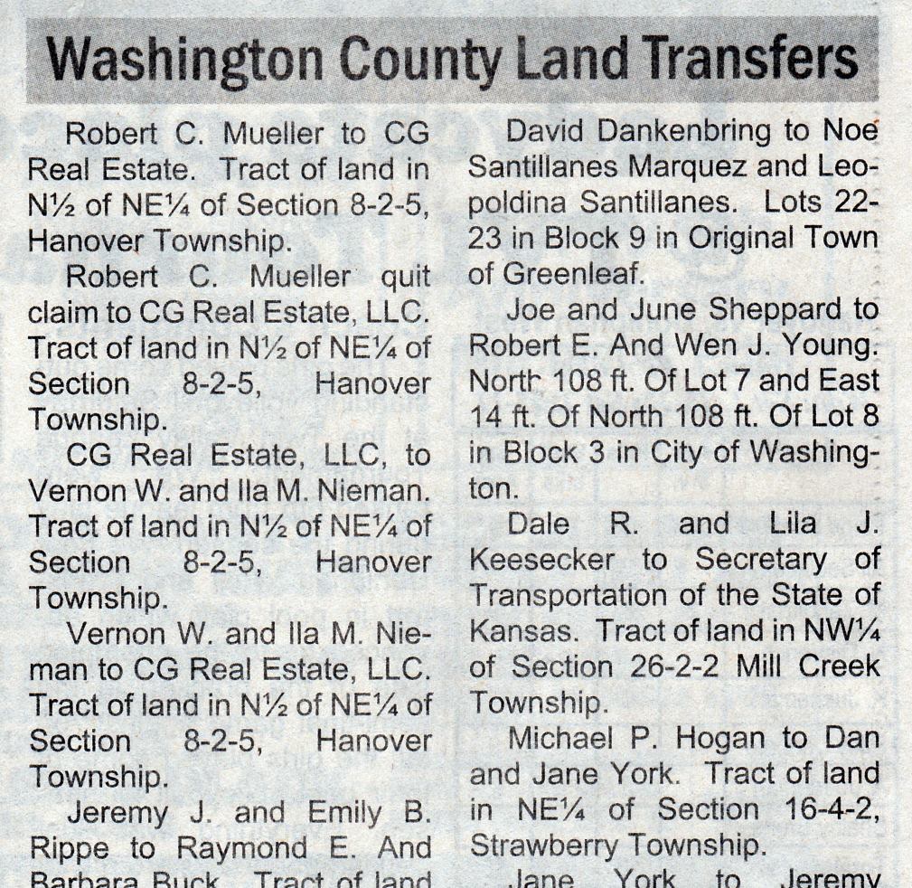
And another huge benefit. You’ll be able to read the Land Transfers section in The Hanover News.
Nibbles Extra Credit
Find Frank Teply’s farm from the land description on this 1909 deed.
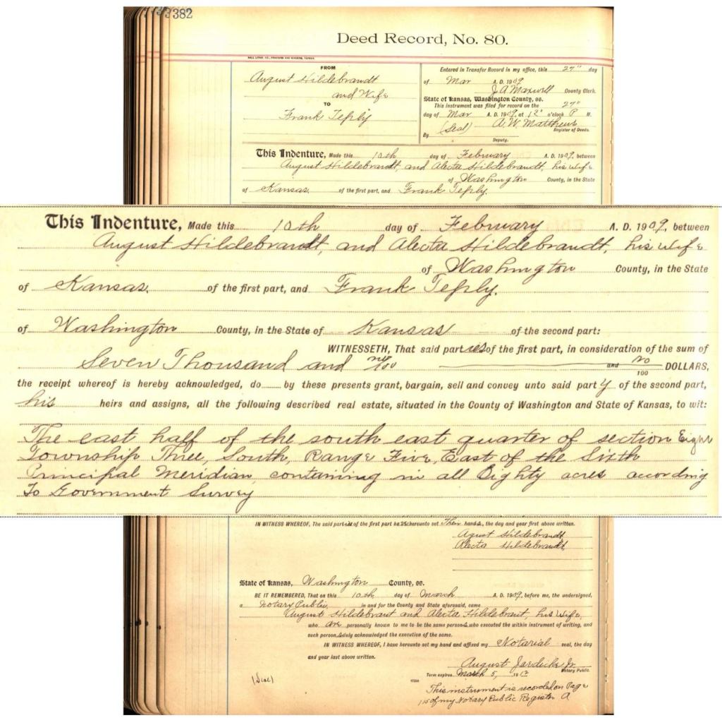
“… of Washington County, in the State of Kansas…”
“The east half of the south east quarter of Section Eight, Township Three South, Range Five East of the Sixth Principal Meridian, containing in all Eighty acres according to Government Survey.”

More Nibbles Extra Credit
The original colonies used the British system of metes and bounds. A land description might be:
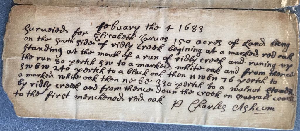
“Surveyed for Elisabeth Jarves 150 acres of Land being on the south side of Ridly Creek beginning at a marked red oak standing at the mouth of a run of Ridly Creek and running up the run 80 pertch SW to a marked white oak and from thence SW b W 240 pertch to a black oak then NW b N 76 pertch to a marked white oak then NE b E 330 pertch to a walnut standing by Ridly Creek and from thence down the creek on several courses to the first mentioned red oak.”
That system is too arbitrary. Years later, the various marked trees are gone, or Ridly Creek has changed course or dried up.
PLSS – Public Land Survey System
The Public Land Survey System (PLSS) is a way of subdividing and describing land in the United States.
Originally proposed by Thomas Jefferson, the PLSS began shortly after the Revolutionary War, when the Federal government became responsible for large areas west of the thirteen original colonies.
Over the past two centuries, almost 1.5 billion acres have been surveyed into townships and sections.


Sources
- Deed – Joseph Swoboda from Patrick Quigley – 160 acres Marshall 20 2 6 – 1875 – DS P520 – Marshall County Kansas – Register of Deeds
- Map – Northeast Counties of Kansas – Historical Plat Book of Washington County Kansas – W.M. Bird – 1882 – https://www.kansasmemory.org/item/224012/page/11
- Map – Marshall County Townships – Atlas of Marshall County Kansas – Anderson Publishing – Page 3 – 1922 – https://www.kansasmemory.org/item/223995/page/3
- Map – Marshall County Kansas – Logan Township – Atlas of Marshall County Kansas – Anderson Publishing – Page 15 – 1922 – https://www.kansasmemory.org/item/223995/page/15
- Deed – Frank Teply Agreement from August Hildebrandt – 80 acres Washington 8-3-5 – 1909 – D80 P382 – Washington County Kansas – Register of Deeds
- Map – Washington County Kansas – Little Blue Township – 1927
- Washington County Land Transfers – The Hanover News – October 15, 2017
- Township description – https://www.arcgis.com/home/item.html?id=5b6fd9ba48c24c289a0ee1173c5d1a55
- Patent Survey – Elizabeth Jarvis – Chester County Pennsylvania – 1683 – Book A-26 pg 172 – Back
- The Public Land Survey System – USGS – https://nationalmap.gov/small_scale/a_plss.html

One thought on “37 – SE 1/4 of Section 20 T2S R6E”